


Let's explore the unique benefits of mobile mapping devices for as-built documentation, together with some hard numbers on how they can help your projects.
This article is part of a series about mobile mapping for experienced laser scanning professionals looking to make the jump to this new technology.
In an earlier article, we gave a quick overview of mobile mappers, and the technology that makes reality capture at a walking speed possible.
In this article, we'll explore the unique benefits of these tools for as-built documentation. Then, we’ll finish up with some hard numbers that quantify exactly how much these tools can help your projects.
Benefits of mobile mappers
Mobile mapping devices offer benefits across the as-built documentation workflow. In addition to streamlining the capture stage when you’re in the field, they offer a variety of features and functionality that can improve your workflow downstream.
1. Speed
Using a terrestrial laser scanner (TLS) to capture a building requires planning the scanner position, setting it up, and breaking it back down – over and over again. Since you might repeat these steps dozens or hundreds of times while capturing a single building, the time saved by using a mobile mapper can be significant. In typical projects, we've seen mobile mapping devices offer a speed increase of 10X over terrestrial scanning.
2. Versatility
Mobile mappers can handle a wide variety of indoor environments, from large, open spaces like auditoriums and warehouses, to narrow spaces like mechanical, electrical, and plumbing (MEP) rooms, and multi-floor spaces with staircases. That means a mobile mapper can be the primary device for your building capture workflow – minimizing the time spent switching between different devices on the job site.
3. Feedback in the field
Most mobile mapping devices use the tablet interface to show your scan trajectory and give intuitive visual feedback about which areas have been scanned. If any areas were missed, for instance if part of a room was not captured due to an occlusion, this missing data will be clearly indicated on the display. Some tablet interfaces also feature advanced algorithms that can indicate the quality of the scan data you have captured, show the locations where panoramic images were taken, and even calculate the accuracy of the scan data using control points.
4. Less time spent on registration
A mobile scanner with hot-swappable batteries enables you to scan at a walking speed for more than an hour. That means you can capture a significant amount of the asset – certain cases up to 3,000 square meters – before beginning another scan. As a result, a mobile mapping device can reduce the number of scans you capture and help limit the time you spend on the tedious step of organizing and lining up your scans in the post-processing stage.
5. Survey-grade results
Today’s mobile mappers don’t require you to sacrifice accuracy or data quality. Our NavVis VLX, for instance, uses advanced processing algorithms to produce low-noise, high-accuracy data suitable for typical as-built documentation needs, such as building information models (BIM) at LOD 300, or floor plans with a scale of up to 1:50. It also offers functionality for locking mobile scan data to surveyed control points to ensure the highest possible accuracy in challenging situations.
6. Easy integration with other capture methodologies
Though mobile mapping devices are designed to be extremely versatile for building capture, no device is suited for every application. For those rare times you need to use another capture method – for instance, when you deploy a UAV to capture the top of building – you can easily combine those data sets with your mobile scans. Simply use a familiar registration method like survey targets to quickly merge your scans for a complete data set that meets all project requirements.
7. Intuitive, photorealistic documentation
The best mobile mappers on the market include a payload of multiple panoramic RGB cameras. These sensors enable the mobile mappers to provide a densely colored, photorealistic 3D data set of the building that's intuitive to navigate and explore, even for those who are totally unfamiliar with point clouds. These data sets can also be shared quickly and easily – enabling stakeholders like draftsmen, project managers, and other end-users to interact with their scanned building through any standard web browser.
By the numbers
To illustrate the benefits of a mobile mapper more concretely, we’ll show how these tools perform in a few typical as-built documentation projects.
Let’s say you are scanning a 1,000 sqm office that includes narrow corridors, staircases, multiple floors, and mechanical, electric, and plumbing (MEP) rooms. Using a tool like NavVis VLX wearable mobile mapper, you could finish the job in one hour and within one data set, with no need for further registration. In more open environments – like a garage – you could go even faster, capturing up to 3,000 sqm in an hour, and one data set.
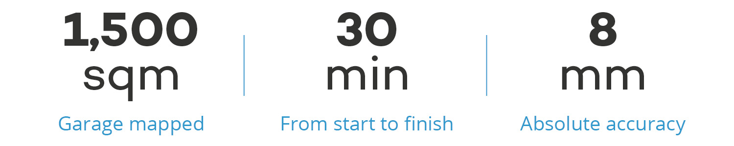
Crucially, this speed doesn’t come at the expense of accuracy. In one test project, we scanned a 1,500 sqm garage in 30 minutes. Without using our control point functionality to optimize the point cloud, we validated the final data set at an absolute accuracy of 8mm, well in line with the requirements of most as-built documentation projects.
If you’re interested in more in-depth information about the performance and accuracy of mobile mappers, browse our content library for more resources on evaluating the accuracy of a mobile mapping system.
Wrapping up
By taking the scanner off the tripod, mobile mappers offer a number of benefits that extend across the as-built documentation workflow—including faster speeds, greater versatility, reduced need for registration, and more. And they do it without sacrificing on the data quality or absolute accuracy your business needs.
This makes mobile mapping devices more than just tools for changing your project workflows. It makes them tools for accomplishing the long-term goals of your scanning business. In the next article, we’ll explore how. In the meantime, you can also download our complimentary resource for using mobile mapping for CAD and BIM as-built documentation.
Sean Higgins is an independent technology writer, former trade publication editor, and outdoors enthusiast. He believes that clear, buzzword-free writing about 3D technologies is a public service.