

See how German chartered engineers Rek & Wieck used NavVis VLX, our new wearable mobile mapping system, to scan a high-rise building project in Berlin.
To test the capabilities of the NavVis VLX prior to launch, select NavVis Mapping Partners were provided with prototype units for assessment. They were invited to use this prototype of our new wearable mobile mapping system in real-world projects and report back their findings. In the second of a series, we’re sharing the experiences and impressions of our NavVis VLX pilots.

“Rek & Wieck is a partnership of engineers,” explains Christof Rek. “To be precise, an association of two publicly chartered engineers. We’re commissioned under public law for tasks such as boundary surveys, segmentation surveys, official layout plans and the like.”
Their business is headquartered in Berlin, Germany, has been operational for over 70 years; since 1949, they have actively participated in the development of this major European capital.
“We’ve done the construction measurements for large building projects such as all governmental buildings, the central train station, the Olympic stadium, and so on,” says Christof, “and now more recently, many private high-rise buildings.”
A partnership from the earliest beginnings
For these projects, Rek & Wieck employ every conceivable technique for building surveying – and that includes the new generation of indoor mobile mapping systems that are a NavVis specialty. The firm has been using NavVis technology for six years and counting.
“We started with the first generation NavVis M3 Indoor Mobile Mapping System,” and here Christof winks and smiles, “which we weren’t entirely satisfied with, to tell the truth, and I stand by that statement.”
Two years ago, they began using the next-generation NavVis M6, and in that time the company has been hugely impressed by its accuracy and the image quality. “With this device we’ve developed new opportunities here in Berlin,” says Christof. “Our clients really appreciate this quality a great deal, as well as NavVis IndoorViewer.”
“We’ve identified a need for more versatility in mobile scanning, and the NavVis VLX bridges that gap.”
As a chartered engineering company of long-standing and reputation, Rek & Wiek feels a duty to help advance and test the development of new technologies in their industry. That’s why they happily accepted the invitation to work with a prototype of the new NavVis VLX wearable mobile mapping system.
“We’ve identified a need for more versatility in mobile scanning, and the NavVis VLX bridges that gap” Christof explains. “I was pleasantly surprised by the quality of the data we’ve gathered with this new device since December 2019, and we’re encouraged to continue using it in the future.”
NavVis VLX reaches the parts other scanners cannot reach
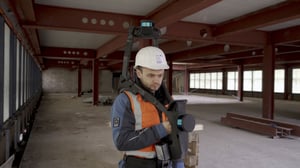
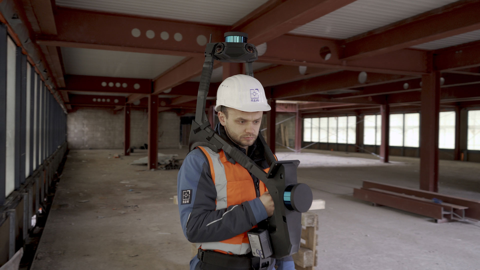
For their real-world testing, the team at Rek & Wieck didn’t go easy on the NavVis VLX prototype. They took the wearable mobile mapping system to a construction site to help scan a building 13 stories tall.
“We’re at the construction site Ernst-Reuter-Platz 6 where the entire block of buildings is being restructured,” explains Aroslav Bilusak, the team lead for 3D Building Information Modeling (BIM) at Rek & Wieck. The challenge with this project is to measure the entire building in three dimensions with a very high accuracy.
“We used the NavVis VLX to conduct various measurements such as staircases and smaller rooms. It’s a lot easier to move through the building site this way.”
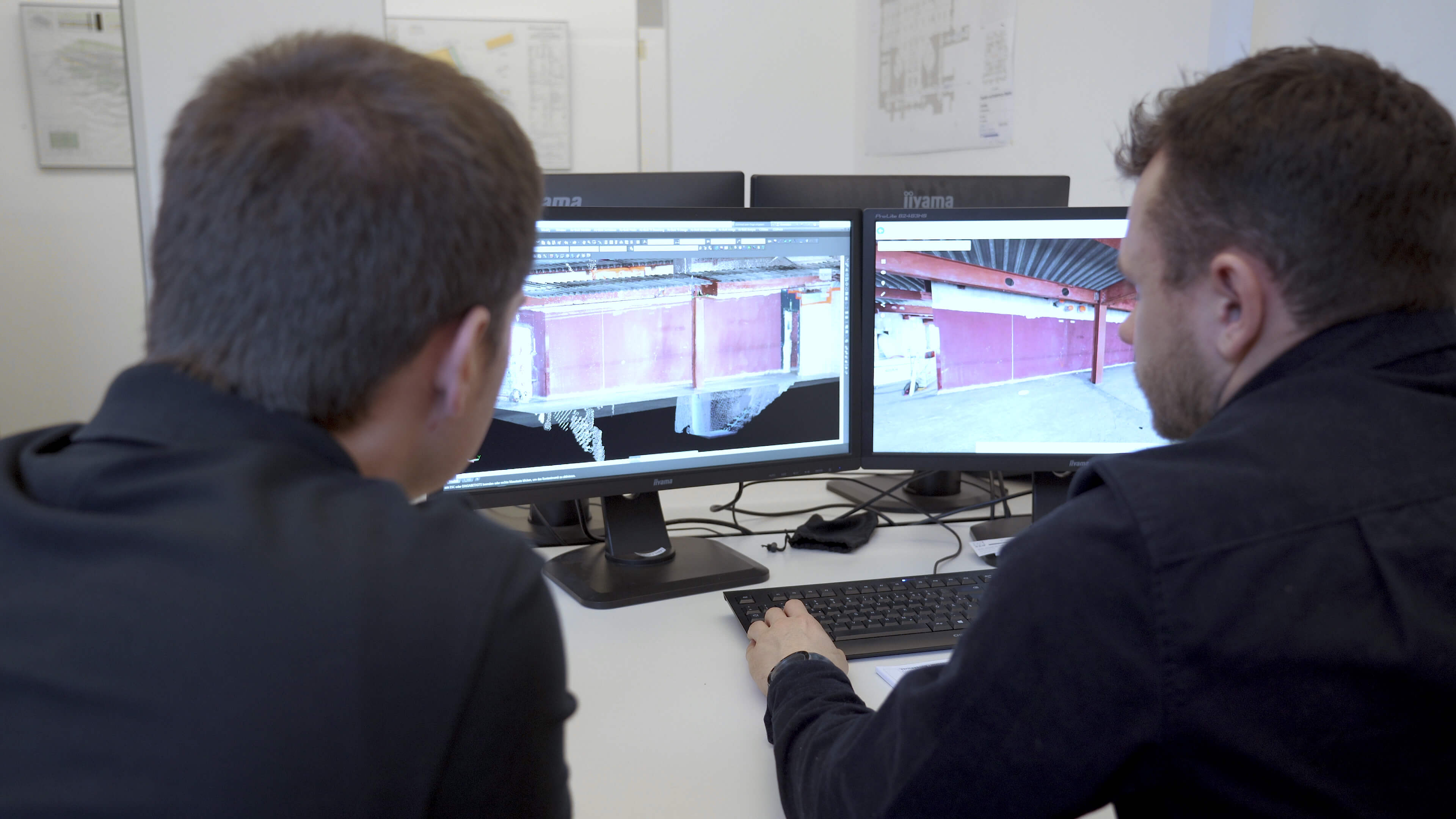
“We’re scanning all 13 floors of the building with a NavVis M6 to capture the entire building in 3D and create a NavVis IndoorViewer instance from that,” says Aroslav. In addition, they had to document all the steel beams with every single opening to enable the reconstruction.
The NavVis VLX, meanwhile, is the perfect complement to areas more difficult to reach. “We used the NavVis VLX to conduct various additional measurements such as staircases and smaller rooms, or where we had too many obstacles on the construction site,” continues Aroslav. “It’s a lot easier to move through the building site this way.”
NavVis VLX is a perfect complement for the NavVis M6
As far as Christof Rek is concerned, their confidence in NavVis since those early experiences with the NavVis M3 has been rewarded. “The point cloud quality from NavVis products is very satisfactory, and we’ve reached a very high level of accuracy.”
Looking to the future, the firm intends to add a NavVis VLX to their inventory, and use it together with a NavVis M6 to pursue a dual strategy of technical advancements and economic efficiencies.
“To me, the NavVis VLX ideally complements the NavVis M6, and it’s an advancement that also promises a lot of financial benefits."
“To me, the NavVis VLX ideally complements the NavVis M6, and it’s an advancement that also promises a lot of financial benefits for us,” says Christof.
“I’m convinced that we’ll be able to employ NavVis VLX side-by-side with NavVis M6 in the future to acquire 3D models of entire buildings – new or as-built – in a very cost-efficient manner.”