Simplify data management by seamlessly integrating 360° panoramas
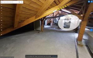
Add 360° pano images from third-party 360° cameras to your NavVis IVION site with an easy, fast, and intuitive browser-based upload. Ideal for regular full-site documentation, the 360° images are automatically placed within your scanned spaces – no extra tools needed. This streamlined workflow keeps point clouds, BIM models and all 360° panoramas centralized, helping you enhance your digital twin without disrupting your existing data management processes.

Facilitate visual updates for construction
Quickly import and automatically position large sets of 360° panoramas to enhance construction verification and documentation. It is compatible with any 360° camera, so everyone in your field crew can capture hard-to-reach areas. Share high-quality visuals to improve stakeholder communication, and support claim management. Centralizing all spatial data in one platform streamlines workflows, reduces complexity, and provides up-to-date site insights to keep your project moving forward.