


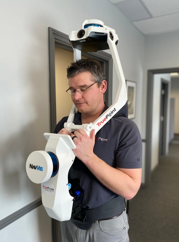
TruePoint uses NavVis VLX for fast reality capture in a newly-constructed office
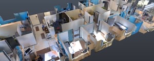
Capturing as-built conditions and HD photos of a state-of-the-art doctor’s office with the NavVis VLX wearable mobile mapping system.
Key takeaways
- TruePoint captured the interior with the NavVis VLX wearable mapping system, which provided a fast scanning workflow and easy capture of HD color imagery.
- The team used a hybrid scanning approach and captured the building exterior with a terrestrial laser scanner.
- Scanning the 3,500 sq ft asset took just over 2.5 hours – one 30-minute scan with NavVis VLX, and 2 hours of scanning with a terrestrial Laser Scanner.
- While walking through the building to scan with NavVis VLX, the specialist manually snapped 40+ color HD panoramic photos.
- TruePoint generated highly detailed as-built documentation for their client’s new office, as well as colorful HD imagery for use in marketing materials.
- NavVis IVION Core gives the client and any future stakeholders remote access to the point clouds and panoramic imagery completely independent of their location – from any smartphone, tablet or laptop.
Eager to learn more about how to integrate mobile mapping into your existing laser scanning workflows?

A short appointment
Since NavVis VLX offers the ability to scan on the move, this means it offered our client another benefit: speed. “We had to scan the building off hours so we wouldn’t interfere with normal business operations,” says Foshee.
“But since NavVis VLX collects data faster than other scanners, this wasn’t a problem. We were able to capture the 3,500 sq ft office in one evening shift – I was finished with the interior in about 30 minutes, and the rest within 2 hours. The whole workflow is shorter, and this got us off site sooner,” he adds.
"I’d say that, on average, NavVis VLX cut our time on site by 50%.”
“NavVis VLX collects data faster than other scanners. We were able to capture the 3,500 sq ft office in about 30 minutes, and the rest within 2 hours. The whole workflow is shorter, and this got us off site sooner. I’d say that, on average, NavVis VLX cut our time on site by 50%.”
Andy FosheeRegional Manager, TruePoint Laser Scanning
.png?width=100&name=Andy%20Foshee%20(TruePoint).png)

Prognosis: Excellent
In the end, TruePoint delivered a single colorized point cloud and 40 HD images for the 3,500 sq ft office. The company uploaded all of these digital assets to NavVis IVION Core for easy access from any standard web browser on a computer, tablet, or phone. This will enable stakeholders to download the point cloud data and imagery as needed for use in offline CAD or BIM platforms on future projects. TruePoint also used NavVis IVION Core to distribute the HD images to the client.
“Our client was very impressed with the 3D data and imagery we provided,” says Foshee.
“They are very excited about the 3D data and using the HD images in their marketing materials. Would this project have been possible without NavVis VLX?” Foshee asks. “Yes – but the device’s ease of use, the ability to scan faster, and the ability to capture colorized HD photos made the whole process much easier.”
“The quality of the true 360-degree photos, point cloud density, along with the 5-10mm global accuracy of the data, allows us to capture a site much faster while still maintaining a level of accuracy that our clients need. I truly believe NavVis VLX will be a game changer in the laser scanning industry.”
Ryan HackerPresident, TruePoint Laser Scanning
.png?width=100&name=Ryan%20Hacker%20(Truepoint).png)

Take the next step in the mobile mapping revolution
The speed and scalability of mobile mapping devices are the best they've ever been, bringing survey-grade accuracy to the most challenging projects. Get hands on with NavVis VLX and see for yourself what's possible.
