PointFuse
SOLution partner
About PointFuse
PointFuse seamlessly integrates with NavVis mobile mapping systems and software, enabling easy collaboration across diverse project teams. They are an integral part of any reality capture workflow, automatically converting point cloud data into intelligent 3D models, enabling users to classify, measure, and share reality capture data quickly and easily. PointFuse features high quality intelligent textured meshes that make reality capture information easier to interpret and manage. Through the creation of meshes, file sizes are reduced by up to 90% and as-built models can be produced 70% faster.
![]()

“We could start with alignment in NavVis IVION, bring the data accurately into PointFuse Pro, and then Revit, without having to do any further translation. This is a great testament to how both of the products work together.”

Mo HaidarFounder, IBKS
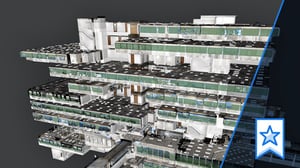
Case study
IBKS pushes the boundaries of scan-to-BIM with NavVis and PointFuse in a towering project