
Industry-leading wearable and handheld laser scanning systems
Our cutting-edge mapping technology enables you to capture detailed, survey-grade data in a variety of environments, both indoors and outdoors.
What can you do with NavVis technology?
See our most popular use cases
Revolutionizing precision and efficiency across industries with advanced 3D laser scanning and software solutions


Construction documentation and verification
Elevate construction project management with our robust software. Track progress, verify structural components, and maintain comprehensive documentation throughout the construction lifecycle for enhanced accuracy and accountability.

Topography
Utilize our advanced scanning solutions for topographic mapping. Create detailed, accurate representations of terrain and landscapes, invaluable for planning, analysis, and environmental assessments.

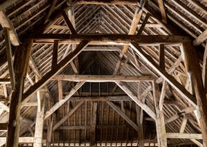
Heritage
Preserve historical sites and artifacts using our precise 3D scanning technology. Capture intricate details for conservation, study, and digital archiving, ensuring cultural heritage is meticulously documented for future generations. And whilst doing so, get in and out in less time if accessibility is an issue.
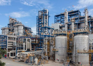
Industrial facilities
Optimize industrial facility management with detailed as-built documentation. Our technology provides accurate representations of existing conditions, crucial for maintenance, expansion, and compliance purposes.
Existing buildings &
building measurement surveys
Enhance real estate and architectural projects with precise building measurement surveys. Our tools offer detailed insights into building dimensions and structures, supporting effective planning and design.

Infrastructure and transportation
Advance infrastructure and transportation projects with our specialized scanning technology. Achieve detailed analysis and modeling of roads, bridges, and public transport systems for improved planning and safety measures.

Simply fill out the form below, and one of our colleagues will be in touch shortly.
Talk to us to discover customized solutions, unique applications, and significant ROI opportunities.
Our experts will clarify pricing details and assist you in optimizing your toolkit and services.
And if you would like a demo, don't hesitate to request one!
“With NavVis VLX, we can race through different floor plates, building sizes, complexities. We’ve had a lot of success with it. We now have four NavVis VLX in operation, every day, 5 hours a day, producing around one to one and a half million sqft of as-built capture per week."
- Adam Fingret, CEO, Extreme Measures Inc.