

What are point clouds? How do you capture them and what do you do with them? Writing for NavVis, independent technology writer Sean Higgins explains it all.
What is a point cloud?
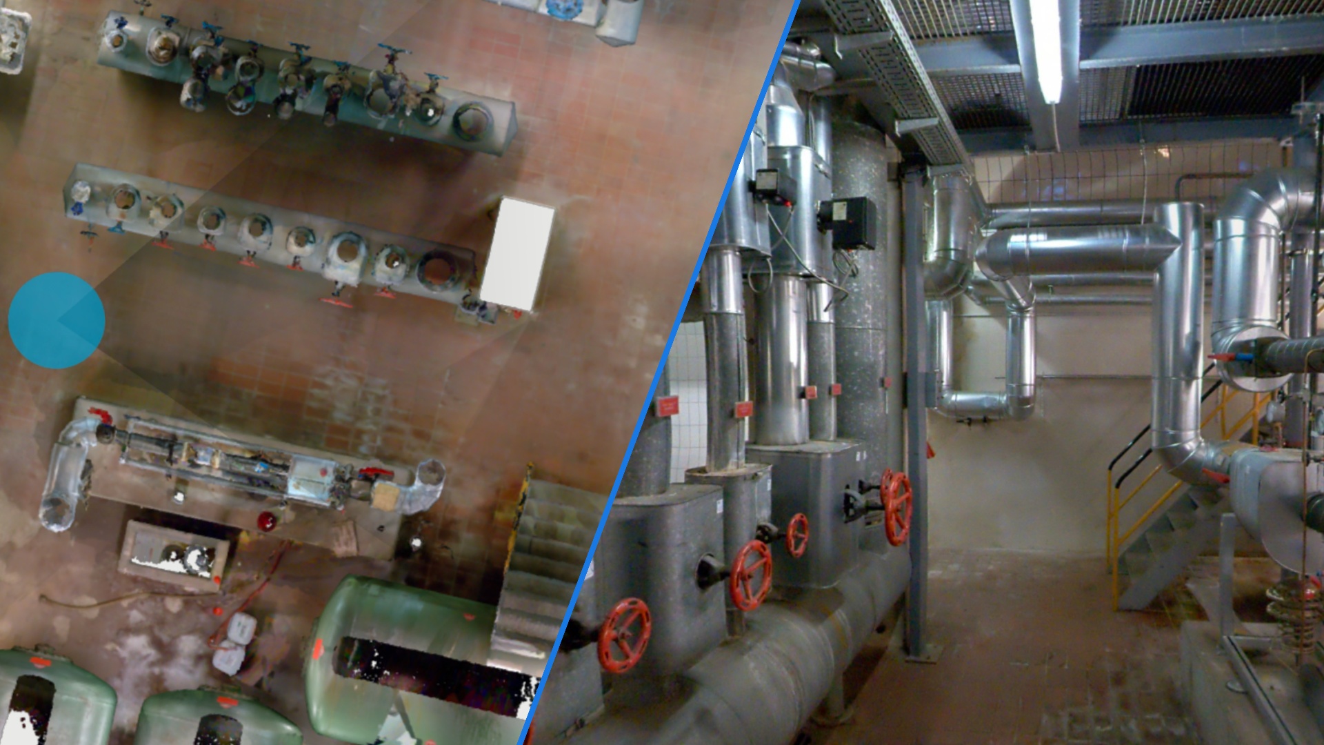
A point cloud is a digital 3D representation of a physical object or space. It's made of millions of individual measurement point cloud data points, each one with an x, y, and z coordinate. The coordinates for each point cloud data point cumulatively make up athe final point cloud which can be then converted into a 3D model or other deliverable
Depending on the method used to capture the cloud – whether it’s through a lidar sensor or advanced photogrammetry – each point can also include RGB color data, or even intensity information, which reflects the return strength of the laser pulse that generated the point. This data collection process is an important part of scanning which will ultimately form the point cloud.
How to generate a point cloud
There are two primary tools you can use to capture a point cloud: 3D laser scanners and photogrammetry.
1. Laser scanners
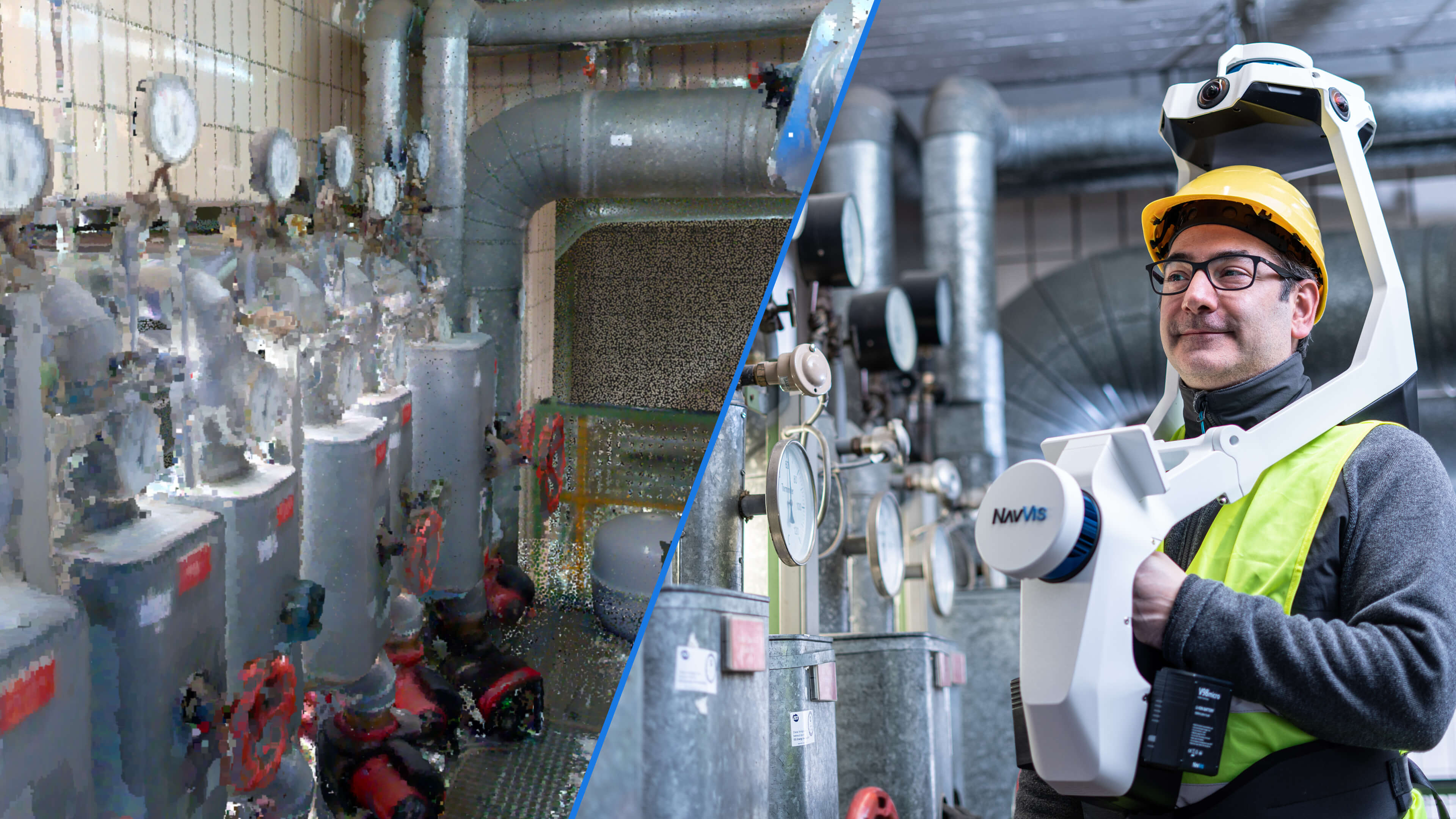
A laser scanner is a survey-grade system that includes a number of different sensors and technologies. The most important is a lidar sensor, which uses rapid laser pulses to gather hundreds of thousands of extremely accurate measurements per second. Most laser scanners also include an RGB camera to add color to the point cloud data and an inertial measurement unit (IMU), which is the professional-grade cousin of the accelerometer in your smartphone.
There are a variety of types of laser scanners, each designed for a specific range of applications. You would use a terrestrial laser scanner (TLS) if you needed to generate point clouds with the absolute highest accuracy for a specialized application like measuring beam deflection, analyzing floor flatness, or capturing a single object like a car or machine with extremely high accuracy.
On the other hand, you would use a mobile laser scanner, which can offer up to 4mm accuracy and enable you to capture point clouds as you walk. This speed makes them ideal for most building documentation projects since they decrease the overall cost per square meter. This speed also makes them ideal for mapping active sites like factories, which offer a small window of time for you to perform your capture workflow.
And those aren’t your only options: The market offers laser scanners for a variety of specialized applications, like capturing objects, roadways, or railways, and even generating wide-area topographic maps. You can use these devices together and join the point clouds into one final point cloud to meet the demands of any project.
Generally speaking, laser scanners produce higher accuracy data than photogrammetry. Lidar technology is an important part of laser scanning and a great method of creating accurate point clouds.
2. Photogrammetry
This is more a methodology than a specific type of tool. To generate a point cloud with photogrammetry, you would cameras to capture the space from all angles and then process those images with specialized software to reconstruct the space in 3D. The software can process the images to create individual point cloud data sets.
If you plan to use drones to capture a point cloud of a building, chances are that you will use photogrammetry. (Lidar technology such as laser scanners are heavy for a drone).
How to use a point cloud data set in the built world
These data sets offer an accurate, precise, and comprehensive digital picture of a real-world space, surface, or object. And that means they offer huge value for a wide range of applications. Understanding how to use point cloud data effectively is an important part of forming accurate deliverables.
Here are just a few of the most common applications for point cloud data in the built world.
1. Floor planning
Point clouds offer you a way to quickly generate a floor plan for a structure. This method is both faster and more accurate than working with survey tools like total stations or manual tools like laser distos. This essentially gathers all of your point cloud data to create a 3D map of the floor plan using specialized software.
How it’s done: There are two methods. You can view the point cloud in a top-down view and trace the floor plan manually using CAD or floor-planning software. Or, you can use AI-powered software can use the point cloud data to generate the floor plan automatically.
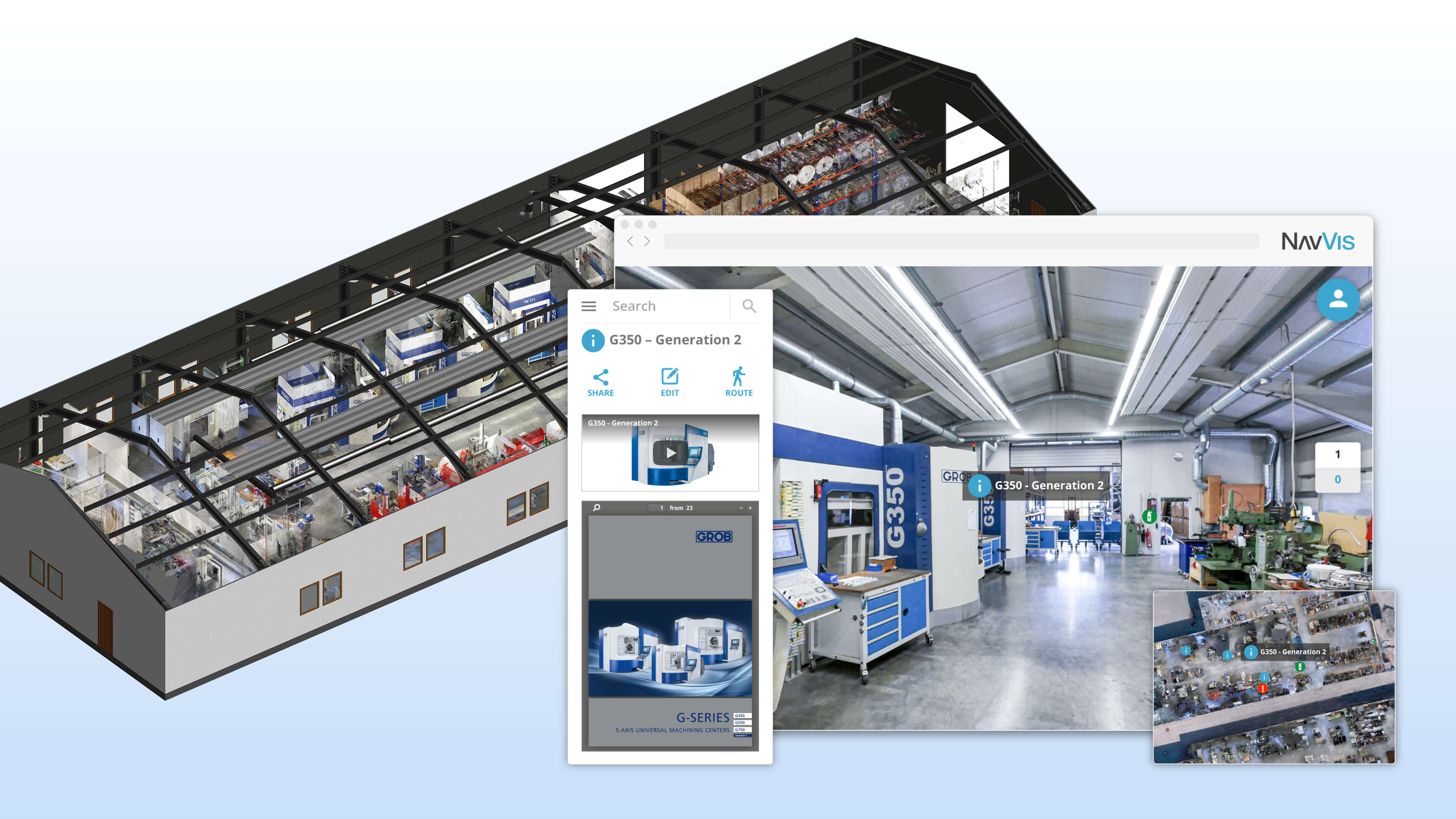
2. Building information modeling (BIM)
Point cloud data is important for creating a building information model. You can use a point cloud to make a building information model (BIM) of your asset. A BIM is “a digital representation of physical and functional characteristics of a facility. A BIM is a shared knowledge resource for information about a facility forming a reliable basis for decisions during its life-cycle; defined as existing from earliest conception to demolition.”
Since a point cloud reflects a building’s “as-is” conditions accurately and comprehensively, this means it offers all the raw spatial data you need to create a new building information model or update an existing model. This enables you to compare the as-is conditions of the building against the “as-designed” to check for errors, conflicts, and clashes.
How it’s done: To generate a BIM from a point cloud, you would use specialized BIM modeling software to generate the model on top of your point cloud data.
Some software enables you to do this manually by drawing elements and encoding information such as material. Other software can partially automate the process by recognizing surfaces, objects, and even MEP, and using AI to generate a model. These semi-automated processes can be very accurate, but they aren’t perfect—the software works much faster than humans do but can miss elements or return false positives. As a result, you will always need to check the work and do some manual corrections to make sure your point cloud data and 3D model is accurate.
You can learn more about this on our extensive guide about the scan-to-BIM process.
3. Construction progress tracking
If you capture point clouds regularly while building progresses, you can use this data to keep track of what work is completed, when it is completed, and where.
How it’s done: There are manual methods for tracking construction progress with a point cloud, and advanced automated methods. You can share the raw point cloud data with stakeholders to give them access to a quick, high-level overview of the building’s progress at any point since building began. Or you can use automatic tools to provide more granular updates, for instance, software that automatically analyzes the point cloud data to recognize specific objects and even goes as far as tracking work against specific trades, schedules, and budgets.
4. Digital twins
You can use a point cloud to create an operational 3D model of the asset. Better known as a digital twin, this model has a symbiotic relationship with the asset enabled by a variety of Internet of Things (IoT) sensors. In an ideal digital twin, any changes in the physical asset are automatically carried over to the digital twin and vice versa. The initial detailed capture of the asset through point cloud data is essential for setting up an accurate and effective digital twin.
This symbiotic relationship means that digital twins can be used like BIM models to review information about the asset or to perform advanced tasks like monitoring, simulation, analytics, and control.
How it’s done: Creating a digital twin is a complex, many-layered process—which is why many companies will offer a service to generate them for you. They will capture the point cloud data, process it and develop a digital twin that fits your specifications and includes the data you need “live” in the model (geometric data, temperature data, and so on).
To learn more about this process, check out a case study with Siemens. It details their project with NavVis to create a digital factory twin that helps multiple stakeholders understand the as-is state of their physical factory.
Wrapping up
This post gives you a definition of what a point cloud is, how they're made, and their typical use cases. What next? If you're feeling adventurous, why not download a sample of point cloud data and explore it for yourself?
Below is a link to our sample point cloud data generated with the NavVis VLX wearable mapping system. This high-quality sample is available to download in the industry standard .e57 file format and is compatible with many third-party CAD (computer-aided design) applications.

Sean Higgins is an independent technology writer, former trade publication editor, and outdoors enthusiast. He believes that clear, buzzword-free writing about 3D technologies is a public service.