


Data processing
Quick, seamless processing of real-world conditions for trusted results.


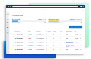
Processing scan data shouldn’t slow you down. With NavVis IVION Processing, you’re in control – choose how and when to process your data so you can save time where it counts. Process multiple datasets in parallel, verify control points early, and generate reliable outputs faster – so you can move from capture to deliverable without delay.
Scale your productivity with intelligent automation. NavVis IVION Processing streamlines your entire processing workflow with automated routines and intelligent error detection capabilities, reducing manual effort. Free up time, minimize rework, and take on more projects without compromising quality or missing deadlines.
NavVis IVION Processing combines robust security with an intuitive user experience. Built-in anonymization supports data compliance, while the streamlined interface ensures reliable results – quickly, confidently, and without complexity.
Point cloud settings
Select the right point cloud settings before processing begins, including resolution, colorization, and environmental parameters, to meet your project’s specific requirements and ensure the output fits seamlessly into your workflow.

Anonymization
Our automated blurring feature quickly anonymizes faces, bodies, and license plates in images and point clouds, ensuring data confidentiality and compliance with standards like GDPR, all while saving you time and effort.

User-friendly
Easily upload datasets with drag-and-drop functionality, set up automatic processing, and monitor progress in real-time with a live progress bar showing processing status and time remaining.
Quality reports
Download a detailed quality report after processing to assess data accuracy, ensure high-quality scans, and boost confidence in deliverables for customers.

Control point validation
Easily geo-register point clouds by uploading a geo-referenced control points file, then verify control points on the quality map to catch errors before processing begins.

Fit-for-Purpose Processing
Economic Processing options for NavVis VLX 3 and NavVis MLX data in NavVis IVION Processing, enabling intentional choices around resolution and visual detail while keeping Dynamic as the standard for precision and QA.

Cross-Dataset Alignment (CDA)
Automatically align multiple datasets during processing, reducing the manual effort traditionally required to register large or complex projects. By optimizing trajectories and identifying shared references across datasets, CDA helps teams achieve reliable, survey-grade alignment with less setup, less rework, and faster project delivery.
