In a guest post, laser scanning professional Matthew Craig explains how NavVis tech is a positive change to traditional work processes in 3D data capture.
In a recent interview that I did with Gene Roe from Lidar News, we discussed my experiences and thoughts regarding NavVis technology. I summarized in the interview that my overall opinion regarding the introduction of their new NavVis VLX system is a step-change in the 3D data capture market.
However, what I did not emphasize in my interview was how the software tool that NavVis developed, NavVis IVION Core (previously known as NavVis IndoorViewer), is just as important as the NavVis VLX hardware. I state this for a multitude of reasons:
-
The ease of use in navigating through the images.
-
The ability to switch between the image view and the 3D point cloud.
-
The ease of use to place tags and add documents and media files to your data set.
-
The ability to customize the user interface that allows customers to personalize the functionality specific to their organization.
-
The ability to add scripts that interface to IoT (Internet of Things) devices to view real-time data.
-
The fact that NavVis IVION Core is a solution that can reside in the cloud or an on-premise server.
The ability to provide customers with this functionality will be a disruptive change in the traditional work processes that customers are accustomed to when contracting services and using 3D data capture technology.
This type of disruption can literally change the 3D data capture services industry by making it more fiscally justifiable for engineering and construction organizations, owner-operators, field services organizations, and others to bring this technology in-house, where in the past they would contract these services out.
The fact that the NavVis technology is the first mobile mapping system that can effectively compete with terrestrial laser systems for some applications makes this possible. This step-change with hardware like NavVis VLX and the disruptive functionality of software like NavVis IVION Core will increase the usage of 3D data capture technology.
Better, Faster, Cheaper, Safer
A key point to remember is that any technology is only an enabler to a work process. Poorly developed work processes, or for that matter, even good work processes that are not followed, or short cuts that have been taken, will render any good hardware or software technology useless.
As I mentioned in the interview with Lidar News, and I will state it again, technology must improve the quality of your deliverables and services, technology must improve the efficiency and timing to execute work-related tasks, technology must lower the cost of executing work-related tasks, and finally, technology must improve the safety of those executing the work. This is summed up by using the old cliche; Better, Faster, Cheaper, Safer.
If the technology does not address all four of these factors, then what is the point of purchasing the technology? Many organizations have invested in technology solutions without ever addressing these four factors. Many purchase technologies based upon what has often been referred to as the WOW factor, which results in looking for a problem the technology can be used for but never going through the due diligence in evaluating technology from a business value perspective. As a result, the companies that sell technology – and the companies that buy technology – develop a black eye, and waste time, money, and resources trying to make technology work, which damages the reputation of a technology.
"The NavVis hardware and software technology solution has improved the time to execute the 3D data capture process by an exponential factor."
The NavVis hardware and software technology solution has improved the time to execute the 3D data capture process by an exponential factor and provides a quality product to visualize and customize asset-tagging features, along with other features. The cost of using 3D data capture services has at times, limited the use of the technology. However, the NavVis technology solution has made it more affordable and provides more use cases to an organization that will potentially bring additional value to an organization that is trying to look for differentiating technologies and services within a competitive market. Finally, the NavVis technology has improved safety by reducing the time it takes to collect the information, thereby mitigating exposure risk within hazardous environments.
The ease of use and functionality of a 3D viewer is only part of the solution, and while NavVis IVION Core does not have the ability to import 3D CAD models, it does have the ability to export 3D point cloud data into a neutral file format (ASTM e57) that can be imported into other third-party plant design software solutions. It also has the ability to import point cloud data from other terrestrial laser scanner platforms via neutral file formats. This allows for interoperability with other point cloud software solutions.
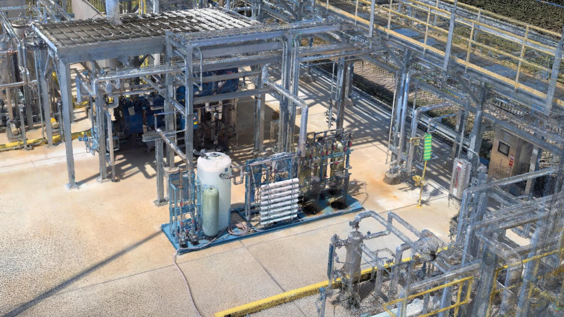
Scanning a state-of-the-art facility with NavVis VLX
Point cloud animation created with #NUBIGON
My career working in the 3D data capture market has spanned over 25 plus years, but it has not been in just one area of the market. I have worked with multiple 3D data capture systems as a service provider, and I have worked as an end-user of 3D data capture deliverables for two engineering and construction companies. In addition, I have worked for a software company that developed and sold 3D data capture software solutions to service organizations, engineering and construction companies, as well as owner-operators. However, prior to all this experience, I had a 15-year career working as a structural designer and a systems analyst in the engineering computer systems group for a major engineering and construction company. This 40+ year career has provided me with a unique perspective on evaluating new technology and understanding the value-added use case for implementing technology into production.
"Students thought NavVis IVION Core was a much more user friendly and easier to use application than other 3D visualization tools."
The use case that was referenced in the interview with Lidar News, was at the San Jacinto College Center of Petrochemical, Energy, and Technology (CPET) Glycol Unit in Pasadena, TX. This state-of-the-art education facility provides a fully operational unit to instruct students who plan to go into the plant operations and services career field. This facility was not only a great testing ground to compare traditional terrestrial laser scanning solution and the NavVis VLX system, but having students using two different end-user viewing tools, provided a great evaluation of the NavVis IVION Core software’s ease of use and functionality. In talking to the college instructors, the students thought the NavVis IVION Core was a much more user friendly and easier to use application than other 3D visualization tools.
I would highly recommend anyone who is seriously considering using 3D data capture technology for documenting and managing the existing conditions of their facility, and for support of capital project work, and for construction progressing, to consider evaluating the NavVis VLX mobile mapping hardware, and the NavVis IVION Core software. You will find that it will improve the quality of your work, reduce the time to capture the information, lower the cost of executing the work, and mitigate safety risks by reducing the exposure time in a hazardous environment (Better, Faster, Cheaper, Safer).
Matthew Craig is the owner and president of Visual Precision Solutions. For the past 25 years, Matthew has specialized in hardware and software technologies that focus on 3D data capture and precision measurement for the industrial market.