
.jpg?width=300&name=NavVis-people0148%20(1).jpg)
For most hardware devices today, from smartphones to robot vacuum cleaners, the driving force behind what makes them so powerful isn’t just the device itself. It’s more often the software. Some have called this trend “software eating the world,” and it even spans to the world of survey and documentation tools.
NavVis VLX was introduced to the market about two and a half years ago, but the device you receive today would not be the same as the device you have now. That’s because the tool continuously evolves long after the initial purchase - thanks to the software. Rather than simply offering firmware updates for maintenance or bug fixes, we continually supply software updates that improve data quality and usability.
Let’s dive into exactly what’s changed and how it benefits you.
An updated user interface
The first piece of the device that we’ve continuously improved via software updates since the initial launch is the user interface. Not only does the user interface help ensure comprehensive data capture, but with an optimized user experience, it can actually help you save time back in the office.
With the ability to thoroughly inspect datasets, edit or delete data, and learn about the device directly on NavVis VLX’s user interface, the chance of capturing incorrect or missed data is significantly reduced. It also helps reduce the need for multiple site visits as you can easily understand scanning coverage on the device itself. This enhanced user experience delivered through software updates allows users to respond better to customer workflow challenges and helps a wide variety of users capture better data.
This value-add comes from updates such as:
- Users can navigate through and inspect datasets while scanning: Being able to pan, rotate, and zoom allows users to thoroughly inspect the point cloud density. This ensures that no areas of the environment are missed during a scanning project.
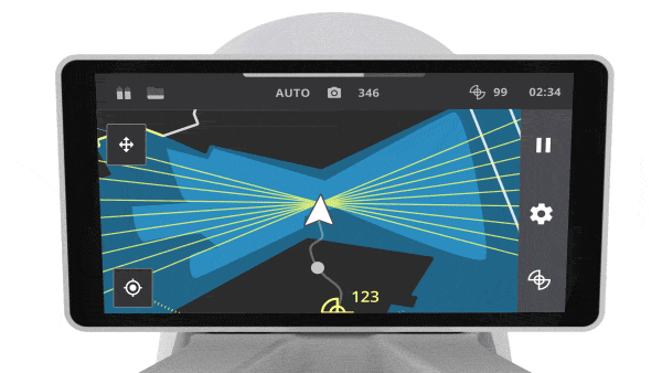
- Users can change the floors while the scan is paused: This allows them to check their point cloud quality on each floor and look for any areas they may have missed while scanning, saving them from having to return to the environment and re-scan.

- Users can edit or delete captured control points: This allows users to fix any mistakes right on the spot instead of waiting to get back to their desks to manually edit control point files.

- Users can review panoramic images: Captured images can be checked out during and after the mapping and can also be deleted when necessary to save time during data processing.

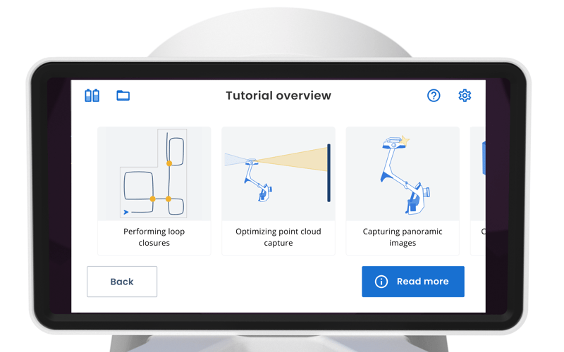
- Users can easily learn how to use NavVis VLX thanks to onboarding tutorials: Users can educate themselves on how to use the device while wearing it, without any additional training or internet connection, to ensure that every user can effectively operate the device and capture high-quality data.
Improved imagery
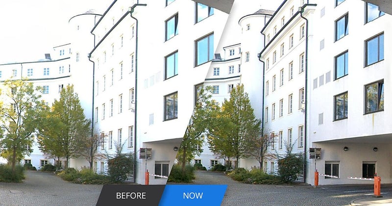
Another software improvement we’ve made to the NavVis VLX System Software has been the introduction of high dynamic range (HDR) imaging for significant enhancements to image and panorama quality.
Images captured by NavVis VLX are post-processed using state-of-the-art HDR imaging techniques to produce more appealing images. This results in a higher image quality that is especially visible around overexposed areas such as around windows, in low-light areas, and in outdoor conditions, particularly on sunny days.
But the biggest improvement overall: quality
All the features and changes we have made to NavVis VLX have added up to one important, all-encompassing improvement: an increase in quality.
.jpg?width=800&height=450&name=baufritz-sample-data-banner-SM-and-feature%20(1).jpg)
Our point cloud accuracy has improved significantly. Starting at a local accuracy of 8 mm, it has dropped down to 6 mm, due to the enhancements to our SLAM algorithms and improvements to device calibration. This accuracy was even put to the test in a whitepaper we published, where we scanned an outdoor 635 sqm façade and conducted a full cloud-to-cloud comparison. We found that 68% of the captured points were within a 5.6 mm deviation from the ground truth and 95% of the points were within a deviation of 12.2 mm from the ground truth.
Additionally, our dataset sizes have decreased by 30%, shortening the time needed to upload datasets to the Cloud Processing Add-on for NavVis IVION and requiring less storage space.
These, coupled with the optimization of our panoramic image quality and user experience, have truly made a difference to our customers and partners around the world. More use cases have been unlocked, scanning outdoors in complex environments, like construction sites, is now possible, and our solution has transformed laser scanning businesses.
Software means longevity for your device
We’ve gone over a lot of incredible updates we made to our NavVis System Software since its launch in 2020.
But, if you take one thing away from this article, let it be this: a mapping system that relies on software for optimization is not a static piece of equipment. It’s not a piece of set hardware with set firmware that will never change, gain new features, or improve after the day you buy it. It’s a dynamic tool that can evolve long after the release date, getting even better as we learn, incorporate feedback, and improve our products over time.