

In the laser scanning industry, we often treat accuracy as the most important factor in data quality. The truth is, there’s a lot more to a survey-grade point cloud than correct measurements.
NavVis has spent the past five years tweaking, honing, and steadily improving its post-processing software. Today, this tool employs a variety of smart techniques to filter noise, re-construct surfaces with class-leading detail, and apply realistic colors and textures. In short, it produces point clouds that are high quality by any metric.
To illustrate how the software works – and what makes it different – let’s look at six ways that the tool processes your raw data to generate an ultimate quality point cloud.
1. It removes dynamic objects
When you import your raw data into NavVis post-processing software, the tool begins by applying treatments to each individual point based on properties like angle, signal strength, and so on. The most obvious treatment, and the one with a significant impact on the quality of your data, is the dynamic object removal filter.
The filter removes objects that may have moved through your field of view during the scanning process, for instance pedestrians, vehicles, or doors that have opened or closed. Since these objects are not the part of the environment you are trying to capture with your scanner, their presence in the point cloud makes them nothing more than annoying, distracting noise.
NavVis processing corrects this problem by exploiting one of the primary operating principles of mobile mapping: The technology requires you to move around the room while you’re capturing.
This means the mapper captures every object from multiple angles. The NavVis post-processing tool uses this information to “observe” each point in your point cloud, and then calculate the probability that it is dynamic or static.
Here’s a very simplified explanation:
- When a point remains in the same position: The filter calculates that the point is very likely to be part a static object, such as a wall. NavVis software keeps the data.
- When a point that does not remain in the same position: The filter calculates that the point is likely to be part of a dynamic object, such as a pedestrian. NavVis software removes the data.
Because the software uses a smart filter that checks each point individually, it won’t remove big chunks of data that you actually want to keep in the point cloud. NavVis has tuned the filter to remove only objects that have a very high probability of being dynamic. Even with this conservative approach, the tool removes quite a bit of unwanted noise from the point cloud and simplifies your workflow significantly.
2. It discards artifacts and bad points
NavVis software applies a range of other filters that remove outliers and erroneous points from your point cloud. There are too many filters to cover each individually, so here are a few quick examples of artifacts that you can expect to see removed from your point cloud:
- Noise around the edge of an object: Otherwise known as “fringe” or “mixed pixels,” this problem results when a laser measurement is split, hitting both the edge of an object and the background behind it. Since the scanner can see that edge from multiple angles, the software can easily filter the noise out.
- Reflections: These are the errant points that a scanner can record when it fires a laser into a mirror, a reflective window, or a piece of metal, and measures the reflection as a real-world object.
- Evidence of the operator: Since a mobile mapper uses multiple overlapping sensors to capture data, the operator can sometimes show up in the raw data before post-processing. NavVis software removes this, too.
3. It reconstructs low-noise, high-detail surfaces
“At the end of this sophisticated filtering process,” jokes Head of Perception and Mapping Stefan Romberg, “the software has removed all the wrong points and kept the right ones.” Now the tool begins the next stage of processing: removing sensor noise while retaining high levels of detail.
That’s trickier than it sounds. As recently as three years ago, NavVis software used strong filtering and smoothing to construct surfaces that were as noise free as possible. But the company quickly found that reducing noise so aggressively was also making details fuzzy or eliminating them completely. This was a deal-breaker for customers who wanted to see small objects like light switches, spray sprinklers, and knobs in their data.
So the company is working continuously to strike a careful balance between noise reduction and detail presentation. (They have actually doubled down on their efforts in this area starting in 2020). Today, NavVis surface-reconstruction techniques accept some noise – but not too much – so you can see every detail you’re looking for in your point cloud.
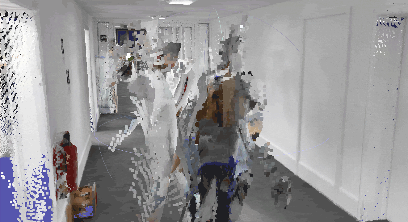
An example of dynamic object removal in action.
4. It generates “thin” point clouds for ease of use
When all the post-processing and filtering is complete, the data is near the end of the pipeline. In its current state, the point cloud is uncolored, and renders walls, floors, ceilings, and other surfaces as thin, single slices.
There are multiple benefits to this “thin” point cloud:
- Since the noise in the un-processed data has been reduced, the “thin” line of each surface is a more accurate representation of the actual surface.
- This means you can take highly accurate measurements between surfaces that are much more precise than you could get with the un-processed data.
- The “thin” point cloud reduces the number of points significantly while carrying virtually all the same information as the un-processed data.
- The file size is significantly smaller, takes less storage space, and loads much faster in your other applications.
- It also makes modeling much easier. If you are drawing floors manually, for instance, it’s easier to see where you should start the line. If you’re using a tool to model automatically, this point cloud makes it much faster and easier for them to operate.
It’s important to note that the “thin” point cloud doesn’t include any “painted” or “invented” surfaces. The data in your final point cloud is all generated based on real measurements, and great care is taken to maintain a high level of accuracy. In other words, you can know that the point cloud is presenting your asset more or less how it was measured by the scanner – just filtered to retain the points you want and remove the points you don’t.
For those who want to skip the filters for reducing sensor noise, NavVis software also produces a point cloud for you. If that describes you, hold that thought, we’ll get to it in item six.
5. It applies realistic colors and textures
Now that the data has been filtered, the post-processing software applies real-world colors and textures to your point cloud.
The software projects the RGB images captured during the scan onto the un-colorized point cloud data. This helps encode information into the scan data that isn’t purely geometric, which can make it easier to discern where a door is, whether there is a sign on the wall, and so on. Given the value of this texturization, the process is applied to both the point cloud that you can download to use in CAD, GIS, BIM and other end-user tools, as well as the data that you would ultimately explore in NavVis IVION.
Texturizing data is a bigger challenge than you might think, as it requires precision areas such as hardware design, calibration, and post-processing. Here’s a quick overview of what it takes to achieve realistic textures in a final data set:
- Effective exposure compensation: Since the mapping system’s cameras are pointed in different directions, they will often capture the same scene at different exposure values. (Imagine you are in a corridor: The camera on the left might look into a dark room, while the camera on the right looks into a bright window.) To correct for this, the post-processing software needs to adjust the exposure for each and every image, so the colors and textures match perfectly.
- Accurate SLAM: The post-processing tool needs a precise estimate of where the scanner was, and how it was oriented, when it captured each individual image. This is necessary for projecting the images onto the measurement points.
- Very good texturization algorithms: The best results require sub-pixel levels of precision and accuracy.
In fact, good texturization is a very useful indicator of mobile mapper’s general quality. If the tool produces a sharp and crisp point cloud that is clearly textured and colorful, that’s a sign that the solution’s hardware and software have been designed and built with care and precision.
6. It offers a “raw” final point cloud – if you want it
As we mentioned before, the “thin,” colorful and textured point cloud we have described above isn’t right for every application.
That’s why NavVis’ software offers users a final point cloud with no filtering applied for sensor noise. When you select this option, the tool filters your raw data to remove all dynamic objects, artifacts, and other outliers, but does not filter the individual measurements—so you get exactly what the sensor captured.
This final point cloud is also not texturized or colored. It is rendered as intensity data, which indicates the strength of the laser when it returns to the scanner. Since every surface will change the intensity of the laser depending on its color, or what material it’s made out of, this information can be useful for determining the makeup of the environment you are scanning. These point clouds are also preferable in cases where you’re scanning in dark environments, like an unlit basement.
For certain modeling projects, this data can also make it easier to find edges and speed up the workflow.
Wrapping up
NavVis’ solutions are designed to produce the most accurate data possible, but they don’t stop there. The company’s post-processing tool uses a broad range of sophisticated techniques to generate quality point clouds that are the highest quality by any metric. This software removes false measurements and errant points, applies intelligent filters to reduce sensor noise while retaining important details, and applies realistic colors and textures.
With NavVis’ post-processing, you can be certain the point cloud is not only accurate, but also a good, reliable reflection of the real world.

Sean Higgins is an independent technology writer, former trade publication editor, and outdoors enthusiast. He believes that clear, buzzword-free writing about 3D technologies is a public service.