See how multinational construction company Skanska used NavVis VLX to capture the site of the St. Nicholas Church and Shrine in less than 60 minutes.
The original St. Nicholas Church at 155 Cedar Street in New York City was the only place of worship that was destroyed in the attacks on 11 September 2001.
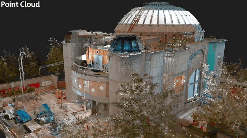
Today a new construction project for the church is being handled by Skanska, a multinational construction and development company, where the NavVis VLX wearable mapping system is used to provide accurate as-built documentation to support spatial coordination at the site.
According to Val Tzvetkov, Senior Regional VDC (Virtual Design and Construction) Manager at Skanska, technicians using NavVis VLX were able to capture the entire floor plan – complete with low ceilings and narrow passages – in less than an hour.
“NavVis VLX captured the compact floor plan with complex multilevel nooks and crannies in less than sixty minutes.”
“To construct the building, prompt and accurate as-built documentation was essential to support spatial coordination,” Tzvetkov explains. “NavVis VLX captured the compact floor plan with complex multilevel nooks and crannies (both images and points) in less than sixty minutes.”
Upon completion, the new St. Nicholas Greek Orthodox Church and National Shrine at 130 Liberty Street will serve as a place of prayer and silent reflection.
Designed by Spanish architect Santiago Calatrava and modeled after Byzantine churches of Hagia Sophia and the Church of the Holy Savior in Istanbul, the new building is designed to glow in the evening hours as a beacon of hope on the World Trade Center campus.
Rapid capture with SLAM is much faster than tripod scanners
Documenting construction work on the new St. Nicholas Church and Shrine is made a lot smoother with NavVis VLX, a wearable mapping system that's more efficient than conventional devices.
“Swifter and more accessible data leads to timely effective decisions,” Tzvetkov says. “Good mobile scanning will significantly reduce capture in field and processing in the office.”
He adds: “To attempt the same with a terrestrial laser scanner would have taken several days.”
Tzvetkov is responsible for all construction technology in Skanska’s annual construction project portfolio in New York, worth around $800M -$1.2B dollars. In this capacity, he implements project-specific digital strategies, standards, and disruptive technology to improve Skanska’s core business.
“SLAM technology allows for the rapid capture of space up to 90 percent faster than terrestrial laser scanning.”
NavVis VLX certainly fits the bill as a disruptive technology, providing professionals in the AEC (Architecture, Engineering and Construction) sector with survey-grade accuracy in a compact, versatile unit. Integral to NavVis VLX are the proprietary SLAM (Simultaneous Localization and Mapping) algorithms that make it possible to map the built environment while simply walking through it.
“SLAM technology allows for the rapid capture of space up to 90 percent faster than terrestrial laser scanning,” says Tzvetkov.
For the past five years, Tzvetkov has overseen all digital technology, BIM and Reality Capture for the $5.1B Design-Built La Guardia Terminal B Redevelopment. The new Terminal B will encompass more than 1.3 million square feet of new facilities, with 35 brand-new gates, 8 miles of new road, and 18 new road bridges.
Image and video credits: Skanska