


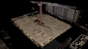
Recently, a good client hired us to perform a floor flatness analysis of a brand-new concrete podium slab measuring over 20,000 sq ft.
This client is a general contractor and was concerned he might have to pay a significant back charge due to imperfections in the slab exceeding tolerance. The next contractor in the sequence was the wood framer, who had strict requirements for the flatness tolerance of the floor. If the framer found that the concrete sloped more than .25 inches (6 mm) in 10 feet (3 m), then he would charge the general contractor — our client — roughly $50,000 for additional work to shim and level the framing.
We captured the concrete surface with our FARO TLS scanner, an industry-standard tool for this application. And we quickly found that the floor was out of tolerance, which enabled our client to pass the back charge back to the responsible contractor.
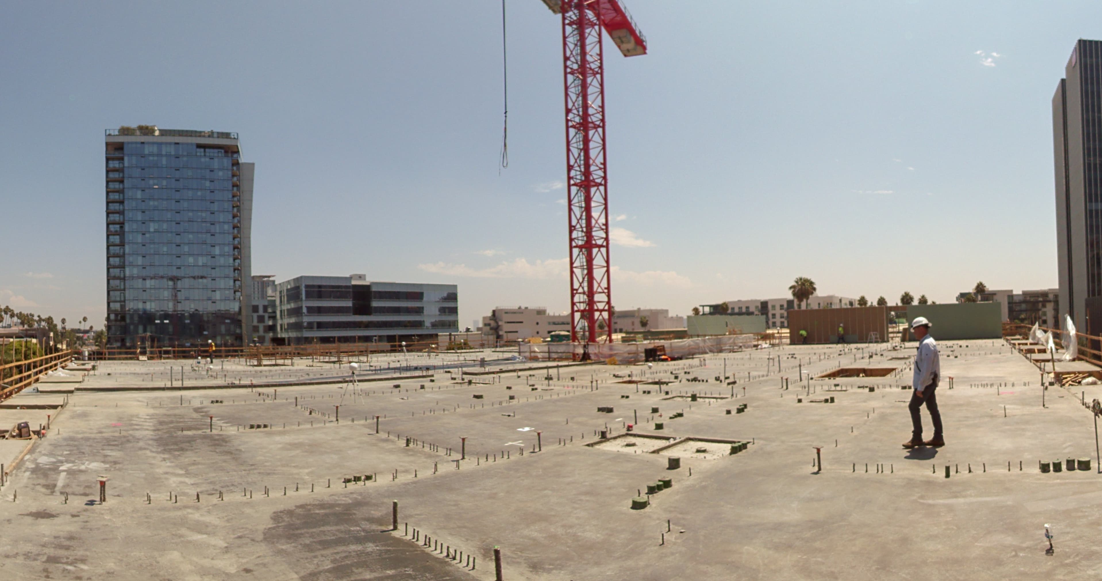
But that wasn't the end of the story. I also had our new NavVis VLX with me on site, so I took an extra 30 minutes to scan the deck quickly, just to see how it would perform.
The results blew me and my whole crew away.
The setup and workflow
For those of you who want to know, here's a quick overview of the workflows for both the TLS and the mobile scanners.
Before any scanning, we placed about a dozen survey control points across the deck. I am a surveyor, after all. Next, we scanned with the FARO TLS, processed and registered the data in FARO's software, converted the file in Autodesk ReCap, and pulled the data into AutoCAD for further work.
Lastly, we used Carlson Point Cloud to create a bare earth model by eliminating points above the surface of the deck. Then we created an 18-inch grid on that surface. At every grid intersection, we had Carlson analyze points within a nine-inch radius and find the average elevation.
We were basically gathering virtual survey points on a grid. With that data, it was simple to produce a contour map in Carlson.
When we tested NavVis VLX, we performed initial processing using the cloud processing add-on for NavVis IVION. From there, the workflow was the same as with our TLS.
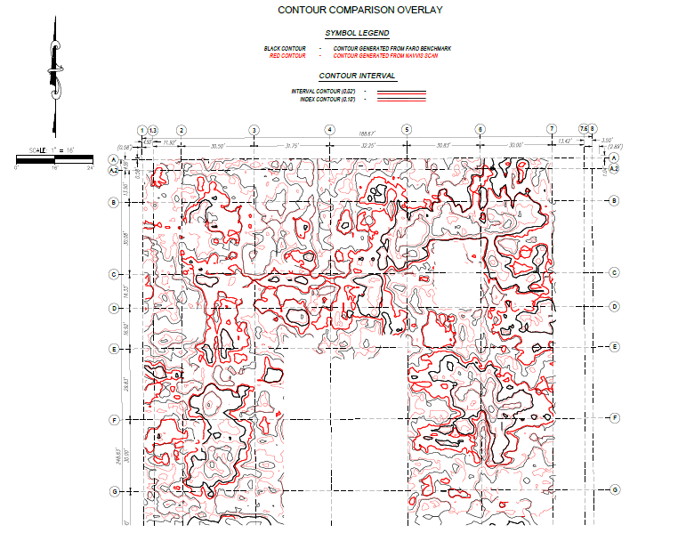
TLS vs. mobile: Full survey control
Our first impression of the NavVis VLX data was that it was not quite as clean as the TLS data. But that was our expectation, and in this application, it wasn’t a problem at all. Since our contour-map workflow uses Carlson Point Cloud to find an average value from a circle with a nine-inch radius, we find that feeding it data from NavVis VLX produces data sets that are more than acceptable for our topo surveys. NavVis VLX matches our survey data all day long.
Even though the mobile mapper works for topo survey, my expectation was that it couldn't match a TLS for floor-flatness analysis. It's just not designed for this kind of work.
On top of that, this was a tough environment for SLAM algorithms. There were few corners, buildings, or other features for the system to latch onto. I fully expected bad results.
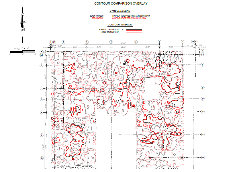
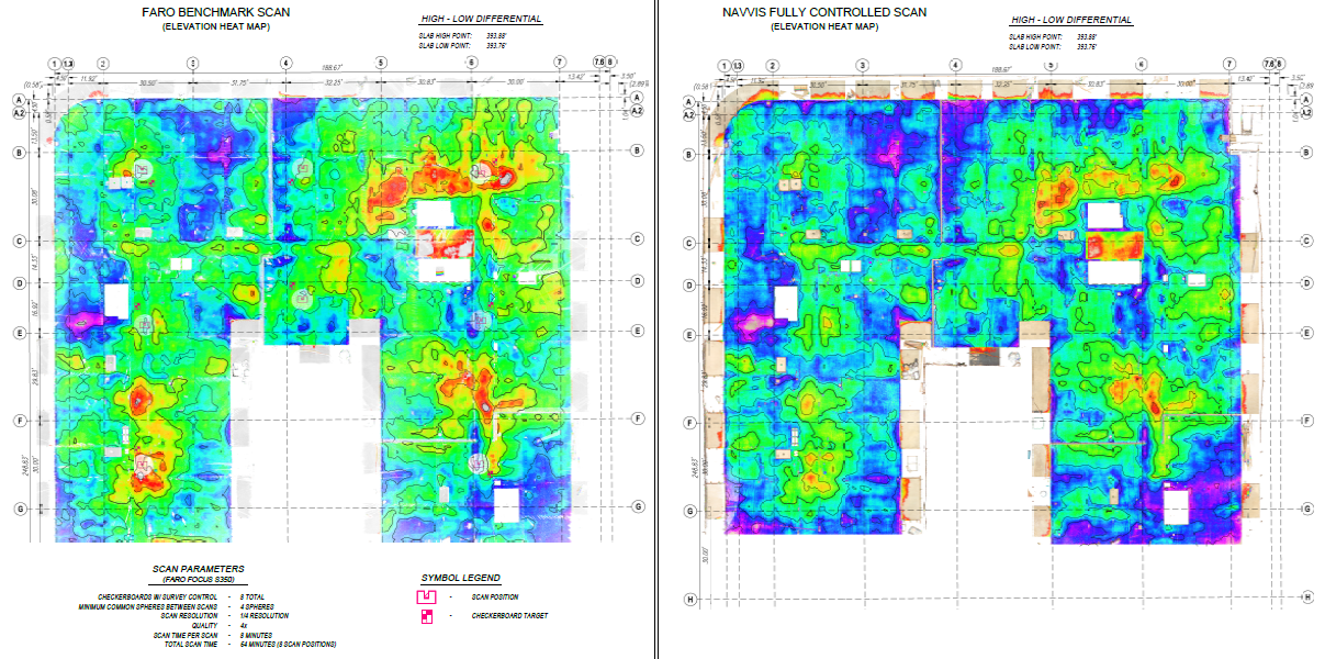
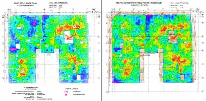
But when we compared the contour map generated by the FARO Focus TLS and NavVis VLX, we were blown away. If you look at the high and low spots on the heat maps, you'll see that the results aren't perfect mirrors, but they're very close.
TLS vs. mobile: Less and less control
I told a colleague about the results, and his first question was: How much survey control did you use? The answer was quite a bit. Then he asked if I knew how the TLS and NavVis VLX data sets would compare with a lot less survey control.
So, I tried the comparison multiple times, with progressively less survey control, to see how far I could push NavVis VLX. Below you'll see the results. On the left is the FARO TLS contour map and on the right is the NavVis VLX contour map.
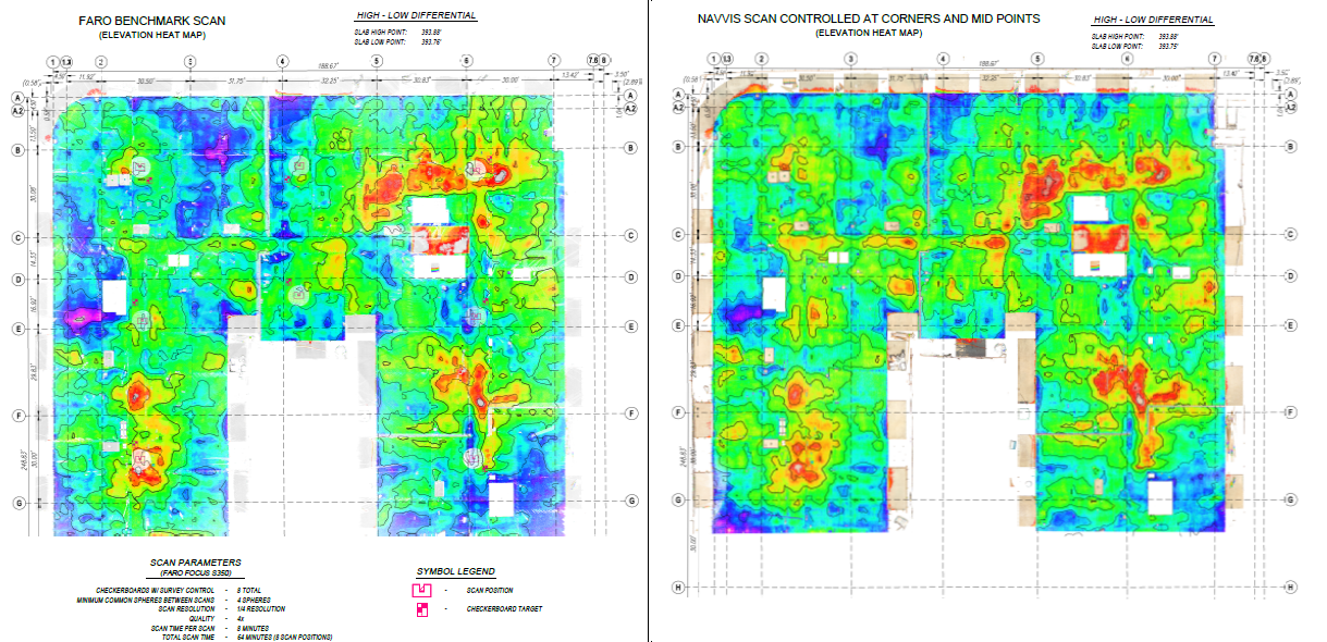
For the example above, we removed survey points everywhere but the corners and sides of the deck, leaving five or six total. For the next, we left control in the corners but removed it from the middle.
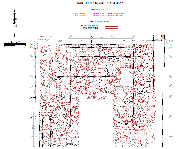
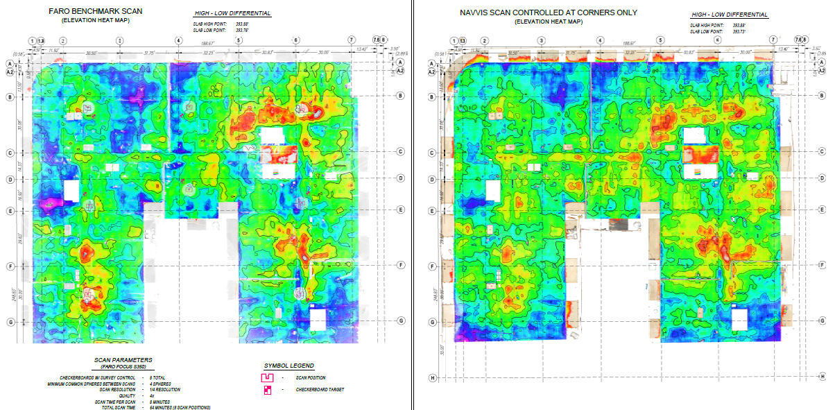
And finally, for the last test, we used just a single control point.
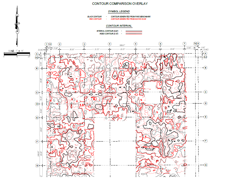
At each point, NavVis VLX exceeded our expectations. As you can see, there's not much to separate the mobile data from the TLS data. That was a big surprise.
The spicy finding
It's important to state that no one is pushing this mobile mapping system as a floor-flatness analysis tool. Again, it's not designed for that application. However, this mobile mapping system was accurate enough to demonstrate that the concrete flooring was out of tolerance and that our client would face a $50,000 charge. Just like the FARO TLS.
That's why I would take NavVis VLX with me as a backup on projects like this. If I were on site and my TLS failed, I would trust that I could rely on the contour data produced by this mobile system.
NavVis VLX is also a great way to capture redundant data — something that surveyors love doing. As it happens, this could have come in handy on this project. A few of the individual TLS scans had lifted and separated, making them difficult to register into a single point cloud. If I needed it, NavVis VLX data could have offered the points I needed to fill in the gaps and helped me to produce a high-quality deliverable.
Think of it this way: You get one opportunity to survey a site with no one around. Spend an extra 30 minutes running your NavVis VLX around as a backup. It's a small investment of time and resources, and you'll get a second data set that you can trust and rely on. And it might make all the difference.
But what's my big takeaway from this test? I didn’t learn that I could swap my TLS for NavVis VLX when I performed floor-flatness analyses. But I did learn that this mobile mapper is a serious and accurate piece of equipment — and I plan on taking it with me on many projects in the future.
To contact Jeff directly for inquiries about the study, their devices, or their services, feel free to reach out to his email and or on Linkedin.