Skip to content
050925-website-casestudy-ETM-6

Accelerating projects and protecting budgets: The value of NavVis for England-Thims & Miller and its clients

Case study
September 2025

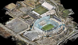
What began as a stadium renovation became a cost and time savings engine.

Key takeaways

  • Cut survey timeline by over two-thirds — ETM reduced a 60-day interior stadium survey to less than 25 days using NavVis VLX 3.
  • Client-requested IVION portal — Live demo led the client to add a dedicated portal, growing from 5 to 70+ active users in one month.
  • Significant cost avoidance — More than $150,000 in direct crew costs saved on the stadium project, with similar results across other jobs.
  • Reusable digital twin environment — Ongoing rescans integrated into the same portal, supporting design changes and multi-disciplinary collaboration.

When Scott A. Graham, PSM, first heard about NavVis, he didn’t get swept up in the hype. As Vice President and Chief Surveyor at England-Thims & Miller (ETM), a Florida-based engineering and surveying firm known for its deep expertise in public infrastructure and land development, he’d seen scanning technology come and go for over two decades.

“Whatever sales reps say,” he said, “divide it in half. That’s probably the reality.”

But Scott’s surveying work included a particularly complex project. ETM had been tapped to support a sweeping renovation of Jacksonville, Florida’s large-scale sports stadium, part of a high-profile public-private partnership between the City of Jacksonville and a major professional football franchise.

The renovation was as much about upgrading a sports facility as it was a broader waterfront redevelopment, one tied to civic revitalization, tourism, and infrastructure investment. His team was asked to provide accurate as-is documentation for the stadium exteriors and, eventually, all six interior levels.

Then the goal posts were moved: over 500 spot elevations were needed inside the stadium, many located in narrow service closets, hallways, and mechanical rooms.

Suddenly, ETM’s longstanding methods for success needed to be expanded. That’s when Scott called Frank Hahnel, a trusted industry contact now working full-time with NavVis.

ETM-case-study-Vertical-Slice-1900px-v2

About England-Thims & Miller:

Scott didn’t want promises. He wanted proof. So he invited Frank to the stadium for a real-world demo.

ETM had already captured terrestrial data in the area, so they compared NavVis VLX 3 to it head-to-head to see how it performed.

The results impressed even Scott: NavVis delivered RMSE values for the vertical component of the point cloud data at 0.017 feet. For comparison, their terrestrial scanner setup came in at 0.014.

But what set NavVis VLX 3 apart wasn’t just the data quality. It was how easily it could fit into ETM’s survey-grade workflow.

Want to learn more about how you can optimize your scan-to-BIM workflows with 3D laser scanning?

From faster scanning to shared reality

ETM initially scanned all six stadium floors over two weeks using its NavVis VLX 3, providing accurate spot elevations as requested.

Previously, Scott had budgeted around 60 field days to capture the same interior scope using traditional static methods. With NavVis VLX 3, that timeline was cut by more than two-thirds.

But the real turning point came after delivery.

Scott and his team realized they were capturing far more spatial data than the project stakeholders had requested. At first, they kept this to themselves, providing all conventional deliverables – floor plans marked up with elevation locations and survey-grade files for documentation.

Then they made a simple suggestion to their client: “You’ve got a lot of people referencing this data. What if we gave it to you visually?”

At the time, the client was skeptical. Years earlier, the city had worked with an engineering contractor who used mobile technology to scan the stadium but had no control integration.

The resulting point cloud was inaccurate, and the viewing software disappointed everyone involved.

Scott knew NavVis was different. ETM offered a live NavVis IVION demo, using their own license. They uploaded just one level and walked stakeholders through it in real time.

It worked. The difference in quality — both in data and in how easy it was to navigate — was immediately clear. So much so that the client formally requested a dedicated NavVis IVION portal as part of the project.

Shortly after, ETM granted their client access to their NavVis IVION instance. What began as a single-scan deliverable became a shared environment used across disciplines, updated on demand as new information was needed. Within a month, the project went from five early viewers to 70+ active users, from architects and engineers to city officials and employees of the professional football franchise itself.

Their one-off scan had become a central source of truth.

"The faster we deliver, the faster stakeholders expect it next time. We've raised the bar on ourselves – and that's good for everyone."

Scott A. Graham, PSMVice President / Chief Surveyor, England-Thims & Miller Surveying & Mapping, Inc

Undeniable results

The numbers coming out of Jacksonville’s stadium renovation tell a compelling story. With a single NavVis VLX 3, ETM trimmed 50–55 field days from the interior survey and avoided already well over $150k in crew costs – immediately paying off the investment in the laser scanner, several times over. 

Since then, finished projects with one NavVis VLX 3 have repeated the pattern:

  • A 20-building multifamily complex that once meant up to five days of static setups was captured, processed, and delivered in roughly a day-and-a-half.
  • Congested urban intersections, previously a traffic-control nightmare, are now documented in one walk-through, giving engineers clash-detection data before anyone files for a lane-closure permit.

That kind of speed reshapes expectations. “The faster we deliver,” Scott Graham says, “the faster stakeholders expect it next time. We’ve raised the bar on ourselves – and that’s good for everyone.”

Why? Because time is interest, and Scott explained just how much LiDAR and SLAM technology is transforming the way large-scale surveys are completed.

For a 500-acre site, what once required up to eight months of traditional “ground and pound” surveying can now be accomplished in just three months with LiDAR technology and ground truthing — all while maintaining, and often improving, accuracy.

This acceleration, he said, is a game-changer for developers, as survey work is a critical-path item that dictates when projects can move forward. By cutting months off the schedule, LiDAR-based survey reduces financing and carrying costs by hundreds of thousands of dollars and accelerates revenue by getting homes to market or businesses open sooner.

In an industry where “time is money” and “time kills all deals,” the ability to deliver surveys saves costs, keeps projects viable, strengthens pro formas, and provides a competitive edge.

Whether the site is a large-scale sports stadium, a downtown intersection, or a blank canvas of pine and palmetto, the pattern is the same: shorter schedules, lower costs, faster decisions. Municipal agencies issue permits sooner, developers reach occupancy earlier, and engineers move ahead knowing existing conditions are already mapped.

With a single NavVis VLX 3, ETM saved

50-55 field days
> $150k in crew costs

About England-Thims & Miller:

ETM (England-Thims & Miller, Inc.) is a leading civil engineering firm renowned for delivering innovative, sustainable, and community-focused infrastructure solutions throughout the state of Florida in the United States. With civil engineering as its core specialty, ETM combines decades of experience with cutting-edge technology to support a wide range of projects—from roadway design and site development to stormwater management and utility planning. Their team of seasoned professionals brings a deep understanding of regulatory requirements and local conditions, enabling them to craft tailored solutions that enhance functionality, safety, and long-term value for both public and private sector clients. ETM’s commitment to excellence and collaborative project delivery has earned it a trusted reputation across the Southeast.

Reality capture as infrastructure

With cost and time savings like these, NavVis has fast become a core part of ETM’s approach, not just for design or planning, but also for GIS, asset mapping, and citywide digital twin initiatives.

In some cases, ETM can use NavVis to scan building interiors with zero survey control, capturing asset locations for GIS with enough precision to be useful, even without tying to geodetic benchmarks. For more complex projects, they tie in NavVis SLAM data with GPS and traditional control to create highly accurate, navigable environments.

That same data can now flow directly into TopoDOT, the software ETM already relies on for extracting features from point clouds. A new integration between NavVis and TopoDOT allows NavVis VLX panoramic images and aligned point clouds to be exported in IPRJ format, eliminating extra steps and smoothing the handoff into CAD-ready workflows.

As Scott sees it, the real opportunity lies in how all these systems – capture, control, processing, and extraction – are starting to work together to create end-to-end spatial records. “Surveyors are the best people to build these systems,” he says. “We know how to check data. We know how to make sure it’s real.”

And as more city agencies and infrastructure owners embrace the idea of living, digital spatial records, solutions like NavVis VLX 3 and NavVis IVION will play a critical role in how projects are planned, maintained, and shared.

Partnering for the next wave

The partnership between NavVis and ETM started with one (understandably) skeptical surveyor asking tough questions – and one dynamic laser scanner that passed every test.

It grew into a new way of thinking about data: not as a static deliverable, but as an evolving, shared environment that supports better decisions across teams, timelines, and project scopes.

That’s what makes NavVis more than a product. In the hands of professionals like Scott A. Graham and his team at England-Thims & Miller, it’s critical digital infrastructure.

050925-website-casestudy-ETM-8

By the Numbers: Saving Time, Labor, and Money with NavVis at ETM

Projects profiled: Stadium renovation, 20-building multi-family site, intersection upgrades, 500-acre greenfield site

Total field day saved (stadium): 50–55 days vs. traditional scanning (from ~60 to ~25 days)

Direct labor cost avoided (stadium): >$150,000 saved 

Accuracy (stadium): Vertical RMSE: NavVis = 0.017 ft vs. static LiDAR = 0.014 ft 

Greenfield interest cost avoided: Illustrative only: up to $800,000 modeled savings on 500-acre site (based on 8 months saved × $100k/month interest)

Multi-family final survey: 5 days (terrestrial) → 1.5 days (NavVis) 

Training time for field teams: ~15 minutes to deploy independently 

NavVis IVION access (stadium): From 5 users to 70+ in one month 

Rescans requested: 5–6 targeted days for structural revisions (integrated into NavVis IVION) 

industry-overview-Abstract-website-hero-2024

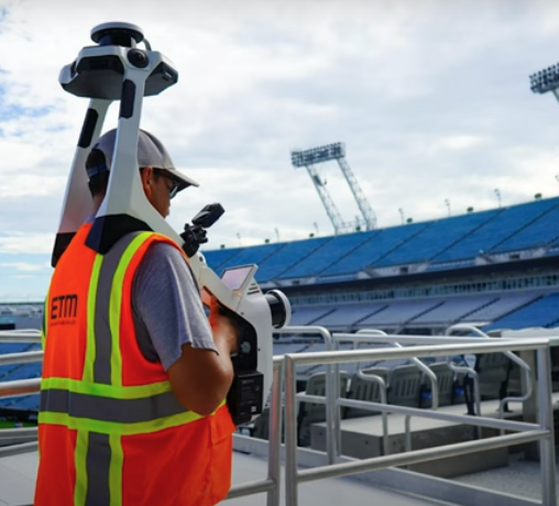
Next generation 3D laser scanning is here

Wearable, 3D laser scanning devices are faster and more scalable than ever before, providing survey-level data quality for even the most demanding projects.

Find out how our entire reality capture solution can benefit your scan-to-BIM workflows by chatting with one of our experts:

Book a demo