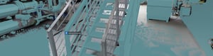
Model validation
Visually compare 3D models, point clouds, and panoramic images within NavVis IVION.
Ensure digital models truly reflect reality. Model validation with NavVis IVION empowers teams to visually compare, measure, and collaborate on discrepancies, delivering confidence, compliance, and clarity from capture to construction.


Easily validate as-is BIM models in NavVis IVION by comparing IFC files with point clouds and 360° panoramas. Predefined coordinate systems ensure accurate alignment, simplifying verification and ensuring that models comply with project requirements regarding LOD and accuracy.

Upload georeferenced IFC models directly into NavVis IVION to compare with point cloud data and 360° panoramic images. With the support of predefined coordinate systems, georeferenced model alignment is precise and seamless, streamlining the verification process and ensuring accurate BIM model positioning.

Use component groups to easily navigate models and quickly identify misalignments or issues. Mark discrepancies within digital sites and share them with BIM/VDC teams for fast resolution, increasing collaboration and reducing miscommunication during the validation process.
Explore the possibilities
Validate the quality of your as-is 3D model
NavVis IVION makes validating the geometric quality of as-is BIM models easy. Visually compare IFC models, point clouds, and 360° imagery within one solution. With support for predefined coordinate systems, the software ensures georeferenced model alignment, simplifies verification, and eliminates the need for third-party tools. Quickly check compliance and project requirements, including LOD and accuracy standards, and annotate issues in the software.
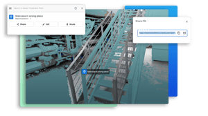
Highlight, share, and resolve deviations between point cloud and 3D model
Use geo-tagged points of interest (POIs) in NavVis IVION to mark discrepancies between your point cloud and 3D model. Add annotations, images, or links, and instantly share deep links to specific locations or measurements. This enables clear, visual communication with your team and stakeholders – streamlining validation, reducing rework, and eliminating the need for external tools or site visits.

Identify, measure and communicate discrepancies with Mark & Measure
Combine 360° panoramas, laser scans, and BIM models to help engineers interact with digital sites as if on site. Identify, mark, and measure deviations between the point cloud and 3D models for precise validation, capturing coordinate data and taking orthogonal measurements. Share findings with your BIM/VDC team or export them in standard file formats, such as .csv or .dxf, for use in third-party solutions, accelerating design validation, clash detection, and collaboration.
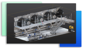
Optimize data handling with focused point cloud sections
Isolate and download selected point cloud sections in various file formats (.e57, .las, .rcs, and more) for use in third-party modeling solutions. Use the 3D crop box with orthographic projection to choose the data you need and spot deviations when validating your 3D model. Reduce data clutter, speed up your modeling process, and enable more precise analysis and cleanup.

Integrations and partners
NavVis IVION integrates with industry-leading third-party solutions to simplify workflows and maximize project efficiency.


NavVis IVION supports the following point cloud formats:


Frequently asked questions
This brief FAQ covers common questions for both new and existing users. For more detailed information, existing customers can explore our Knowledge Base, or new visitors can contact our team directly.
After uploading and aligning a BIM model, compare it to the scan data. Adjust its visibility and appearance using the View Settings or Site Structure panels. Customize colors and visibility for the entire model or specific components to improve clarity. In Mark & Measure mode, use the 3D crop box to create precise slices and easily spot deviations between the model and the point cloud.
NavVis IVION supports IFC files based on the buildingSMART International (bSI) data exchange standards: IFC2X3, IFC4x1, IFC4x2, IFX4x3 RC3.
Use POIs or measurement annotations within NavVis IVION to indicate deviation points. If synced with an integrated Construction Management Platform, e.g. Autodesk Construction Cloud (ACC), POIs become issues and remain synchronized over time.
Resources
Get started with a carefully selected bundle of content - including real-world use cases, expert webinars, and helpful articles.
Head to our Knowledge Base for deeper insights and support.
Download the NavVis IVION resource bundle
Fill out the short form below to receive the resources straight to your inbox:
- Case study: Schiphol Airport and Allinq Digital transform scan to BIM to realize ambitious sustainability goals
- Case study: Schiphol builds a digital twin to achieve an ambitious goal: Become the world’s most sustainable airport by 2030
- Webinar on-demand: Scan-to-BIM im Einsatz bei großen Bauprojekten mit NavVis, Qbitec und Siemens (German)