


Construction verification
Accelerate documentation, reduce rework, and streamline construction verification with NavVis reality capture technology and virtual site access.


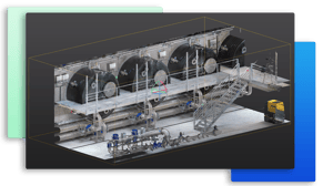
Catch issues early by comparing as-designed models with real-world as-built conditions. Annotate and share discrepancies directly within NavVis IVION to reduce misunderstandings, prevent costly rework, and keep construction projects on track and within budget.
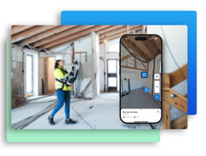
NavVis enables remote access to digital construction sites via browser or mobile app, reducing the need for physical site visits. This increases efficiency, minimizes travel time, and ensures stakeholders can stay informed regardless of their location.
With real-time access to site documentation and progress updates, NavVis can reduce the time needed for Request for Information (RFI) processes. This leads to faster approvals, fewer delays, and reduced administrative overhead — accelerating decision-making across teams.
Highlight and share deviations between point clouds and 3D models
Use points of interest (POIs) to mark and communicate discrepancies between point clouds and 3D models. Document and share issues with supporting text, URLs, annotations, or photos directly within digital sites with geo-tagged, searchable POIs. Promote collaboration, reduce rework, and streamline model validation processes without external tools.

Capture on-site insights and share with your team in real time
NavVis IVION enables teams to verify construction, compare as-built conditions to design intent with point cloud data and BIM models, document on-site status with field notes, and support issue management - all in one streamlined, shareable digital environment.
Download the NavVis IVION Go App today to test it yourself
iOS & Android
Selective download of point clouds for faster quality assurance
Easily isolate and download selected sections of point clouds using the 3D crop box with orthographic projection, and export them in various file formats, such as .e57, .las, .rcs, and more. Crop & Download lets users extract only the data needed for verification tasks, making it easier to coordinate with BIM/VDC and QA/QC teams or use it in third-party modeling solutions. This reduces data clutter and file handling overheads while accelerating model validation, analysis, and cleanup.
Integrations and partners
NavVis IVION integrates with industry-leading third-party solutions to simplify workflows and maximize project efficiency.

