Skip to content
CaseStudy - GeorgeFYoung - 1

How George F. Young turns Reality Capture into a long-term asset

Case study
August 2025

A century-old surveying firm is using dynamic laser scanning to reduce field time, lower costs, and deliver richer, reusable spatial data to its clients.

Key takeaways

  • George F. Young used NavVis VLX to reduce field time from multiple weeks to a single day on key survey projects
  • NavVis VLX scanner paid for itself within a few months
  • The firm shifted from selling hours to delivering high-value spatial data products, improving both client satisfaction and internal margins
  • Scanning became a firm-wide capability, not limited to specialists, accelerating adoption and ROI
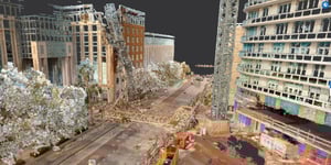
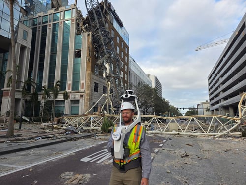
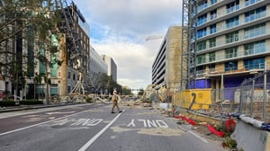
  • During Hurricane Milton recovery efforts, George F. Young delivered critical scan data within 24 hours to support emergency response and interdepartmental coordination
CaseStudy-GeorgeFYoung-2


George F. Young, Inc. (GFY) is a multidisciplinary firm with over 100 years of experience delivering surveying, engineering, and planning services across the southeastern United States. Its licensed surveyors support a wide range of development and infrastructure projects - from municipal utility upgrades to complex urban redevelopment - with services that include boundary, topographic, hydrographic, and construction surveys.

As project scopes grow more complex and turnaround expectations tighten, GFY has steadily expanded its toolkit to deliver efficient, high-quality work while reducing turnaround time and field costs. That includes using laser scanning to complement and optimize conventional workflows.

“We’re seeing more demand for data-rich deliverables and tighter timelines,” said Trevor Hatch, VP of Surveying at GFY. “We wanted to make sure we had the tools that let us respond quickly…without compromising quality or adding weeks of field time.”

CaseStudy-GeorgeFYoung-3-1

A shift in delivery model

The GFY team had already begun integrating scanning into select projects. But when Steven Heise, Senior Vice President of Survey at GFY, joined the firm from California, he brought deeper experience with dynamic SLAM-based scanning (Simultaneous Localization and Mapping).

He had previously worked on large infrastructure projects, including scanning at major sports stadiums and along transit corridors for state-run transportation groups.

That firsthand knowledge helped GFY evaluate several scanning systems before selecting NavVis.

“NavVis’s data was clearly superior,” said Steven. “It was the only solution that gave us the quality we were looking for.”

That assessment was based on several factors GFY recognized during early evaluations, including the system’s accuracy over long ranges, reliability in challenging environments, and robust handling of reflective surfaces - factors that can make or break a scan in dense or complex field conditions.

Once the purchase was made, GFY was scanning live projects within weeks.

Want to learn more about how you can optimize your scan-to-BIM workflows with 3D laser scanning?

“We’re no longer selling hours. We’re selling deliverables.”

For GFY, the introduction of scanning wasn’t just about speed. It also allowed the company to rethink how it prices and delivers certain types of work.

As Trevor explained, "We are able to provide scanning projects as a revenue-generating service, but our focus remains on delivering value to our clients rather than taking advantage of them."

"We can now achieve the same reliable results at a fraction of the cost – saving anywhere from 25% to 88% depending on the project, with no compromise in accuracy or quality.”

"Traditionally, the model for a surveying or engineering company is we sell hours. That’s what we do. With scanning, the model is different. Now we sell a product.

"I used to say, ‘That’s going to take my field crew two weeks.’ Now I can say, ‘That’ll take a day,’ and we’ll process the data and give them something better than we could have before.”

That change isn’t just internal. GFY is helping its clients see the value of spatial data more clearly. When scan deliverables are made accessible, verifiable, and reusable, clients come to make use of it in ways that benefit projects across departments and disciplines.

“We can now achieve the same reliable results at a fraction of the cost – saving anywhere from 25% to 88% depending on the project, with no compromise in accuracy or quality."

Trevor HatchVP of Survey, George F. Young

A response that delivered long-term value

Case in point: Just a few weeks after acquiring their NavVis VLX 3, GFY was asked to document a crane collapse at the 400 Central high-rise in downtown St. Petersburg, following Hurricane Milton.

City officials and insurers needed a full account of the site. GFY was already on the ground the next day.

“They initially asked us to take a bunch of pictures,” said Trevor Hatch. “We said we could do that and scan the entire site while we’re at it.”

The result was a complete, accurately georeferenced (location-tied), and highly detailed record of the affected area that stakeholders could inspect long after the site was cleared. The deliverable also had a broader impact.

“Because we were there and had that scan, we ended up helping redesign the roadway and continued working on the site. But more importantly, the city had the full spatial record of what happened, where everything was, and how it was impacted.”

Instead of a one-off deliverable, the information became foundational data that could be shared, referenced, and built upon across multiple projects and departments. It shifted the conversation from reactive documentation to strategic asset management.

About Survey & Mapping at George F. Young:

GFY has provided the federal government, the State of Florida, counties, cities, and communities with quality surveying and mapping services since 1919. Today, they are recognized as one of the largest land surveying and mapping firms in the state of Florida, with the resources to undertake virtually any surveying and mapping project – whether for high-rise developments in an urban area, vast rural lands, or bathymetric surveys on waterbodies. With experience, quantity, and quality of our staff and extensive company-owned specialized equipment – they provide services on thousands of projects each year.

A working relationship that works

GFY’s successful deployment was supported by Frank Hahnel and Austin Jennee from NavVis. When Steve reached out from Florida, he was quickly connected with the right contacts. From onboarding through execution, communication stayed consistent.

Trevor credits that responsiveness with helping the team get off the ground fast.

“The NavVis team made my life easier,” he said. “We were scanning quickly, and I always knew who to ask if something came up.”

“They initially asked us to take a bunch of pictures,” said Trevor Hatch.

“We said we could do that and scan the entire site while we’re at it.”


- Trevor Hatch | VP of Survey, George F. Young

Precision, when and where it counts

While scanning has opened up new efficiencies, GFY remains careful about how and when it’s used.

“We still use total stations when we need to tie into existing utilities,” said Steven. “You have to understand when a tenth of a foot matters and when it doesn’t. It’s all about knowing your tools and using control properly.”

He also noted that quality control remains a shared responsibility, no matter the method. “Whether you're doing an aerial survey, a topo, or using SLAM, it all comes down to the same thing: you need to know where your data comes from, check your benchmarks, and validate your work.”

CaseStudy-GeorgeFYoung-4-1

Results at a glance

How George F. Young uses NavVis to deliver client results and business returns

Rework & cost

  • Substation scan deliverables delivered at less than 15% of traditional cost
  • Reduced reliance on multiple crews and repeat site visits
  • Scanner paid for itself within a few months

Schedule & efficiency

  • Field time reduced from multiple weeks to a single day on key projects
  • Fast deployment: live scanning within weeks of equipment purchase
  • Broad team adoption eliminated bottlenecks and accelerated turnaround

Ownership & control

  • Shift from billing hours to delivering high-value, client-ready products
  • Scanning became a shared team capability, not tied to a specialist
  • Spatial data reused across departments, aiding decision-making and planning
industry-overview-Abstract-website-hero-2024

Next generation 3D laser scanning is here

Wearable, 3D laser scanning devices are faster and more scalable than ever before, providing survey-level data quality for even the most demanding projects.

Find out how our entire reality capture solution can benefit your scan-to-BIM workflows by chatting with one of our experts:

Book a demo