Skip to content
230831_INTERGEO_hero_reseller_dinner

Unlock the potential trapped in your business

Discover how you can reduce your project time by up to 80% compared to standard industry solutions
Let us help you grow

Unlock the potential trapped in your business

Discover how you can reduce your project time by up to 80% compared to standard industry solutions

Let us help you grow
navvis-campaign-hero2

Podcast

Scanning Realities

Laser-focused insights into the current geospatial landscape and beyond

south-group-case-study-header

How China’s leading surveyor uses 3D reality capture to deliver a fire safety platform

Case study
June 2020

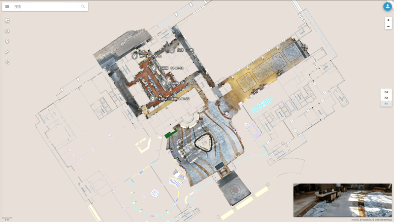
Using high-quality point clouds and 360-degree panoramic images, one of the largest gas operators in China has a digital inspection platform for gas pipes, fire-fighting equipment, safety sensors, and more.

Key takeaways

  • Panoramic images and point clouds captured with NavVis M6 recreate a site in precise detail, where inspectors can assess the location in advance and plan the most efficient route to take in all points of interest.
  • Inspectors use NavVis IndoorViewer on mobile devices on site, visiting each POI and checking relevant inspection forms and notes for immediate context and up-to-date information.
  • Emergency exit routes can be set up and examined in the 2D digital floorplan, and the placement of security equipment like fire extinguishers and breathing apparatus can be optimized for deployment with maximum effectiveness.
  • Large indoor complexes can connect smoke alarms, thermometers and barometers to NavVis IndoorViewer to better visualize safety supervision within the building.
  • The digital inspection platform simplifies inspection, repair and maintenance: through one-click sharing via NavVis IndoorViewer, maintenance personnel can schedule a visit, knowing exactly where the problem is located and the work required, and make repairs on the spot.
south-group

The need for regular fire safety inspections

Modern large-scale urban complexes in mainland China present a unique set of challenges. These sprawling clusters of residential and commercial buildings cover a large geographical area, with highly concentrated numbers of people, which can be dangerous if a fire breaks out.

Flames can spread quickly, making evacuation difficult and even harder for fire-fighters to bring the situation under control, resulting in heavy casualties and property losses. To properly safeguard people’s lives and property, regular fire safety inspections of these complexes are essential.

Eager to learn more about how to integrate mobile mapping into your existing laser scanning workflows?

Talk to an expert

The complexity of gas supervision and management

China Resources Gas Group Limited, otherwise known as CR Gas, is one of the largest gas operators in China. Their activities are comprised of research and development, production, management, sales, after-sales service and solutions of gas-supporting hardware and software.

When conducting inspections in large urban complexes, their teams are required to make detailed checks on fire-fighting equipment, the condition of gas pipes and facilities throughout the complex, and self-certification records of property companies. CR Gas needed a smarter solution for gas supervision and management in terms of efficiency and accuracy.

Enter the NavVis Reality Capture Solution

Laser scanning service provider South Group was contracted by CR Gas to develop such a solution. Specialists from South Group use the NavVis M6 to collect high-quality point clouds and 360-degree panoramic images from each location at speed and scale. Thereafter, the data is uploaded to NavVis IndoorViewer to create an interactive digital twin of the site that’s accessible through a web browser.

According to Lin Shanqiu, CR Gas Manager in Fuzhou, capital city of the Fujian province: “This is an advanced 3D inspection platform which improves efficiency and accuracy for our staff.”

Regular scans of as-built conditions ensures that personnel can conduct accurate inspections according to the set patrol route, location, time, and necessary stops at key junctures. This digital inspection platform guarantees the safe, stable and reliable operation of gas pipes, fire-fighting equipment, safety sensors, and more.

south-group-case-study-1

A digital inspection platform for fire safety

CR Gas is conducting safety inspections at the Jinyuanshiji Exhibition Hotel in Minjiang, Fuzhou, China. Since June 2019, they have been regularly scanning a space of 6,000 square meters at regular intervals with the NavVis M6, so that inspectors are always working with the most current spatial data. They can also select and examine multiple data sets captured at earlier stages, to compare changes made to a site over time.

Planning inspection routes in 2D and 3D

The panoramic images and point cloud data from the NavVis M6 can recreate an inspection site in precise detail. Inspectors can browse the location in advance on any browser or mobile device – seamlessly switching between 2D digital floorplans and immersive 3D digital buildings – and plan the most efficient route in take in every POI like pipelines, pipeline valves, and key equipment and facilities. In the NavVis IndoorViewer instance, personnel can use the measurement tool to quickly acquire heights, widths and volume of a POI.

Real-time updates to Points of Interest (POI)

The inspectors only need to carry mobile devices to the scene to do a visual comparison with NavVis IndoorViewer. Upon visiting each POI in NavVis IndoorViewer, the relevant inspection forms and notes can be added to that POI. After inspection, personnel can upload photos and notes of their findings in real-time, providing immediate context and up-to-date information for the condition of the POI.

Emergency exit planning and placement

Emergency exit routes can be set up and examined overhead in the 2D digital floorplan. The most appropriate exit route can be indicated (and revised) in the context of where the emergency might occur. In addition, the placement of security equipment like fire extinguishers and breathing apparatus can be optimized for deployment with maximum effectiveness. In this way, the inspectors will continually assess how best to safeguard people’s lives and property.

Risk danger warning

Large indoor complexes can connect safety sensors – e.g., smoke alarms, thermometers and barometers – to a custom solution built on top of NavVis IndoorViewer to better visualize safety supervision within the building. This enhances the aspect of prevention and control; the platform will monitor and automatically generate relevant alarm information, such as smoke detection and temperature spikes.

Integrated maintenance service work

Another benefit of the digital inspection platform is how it has simplified inspection, repair and maintenance. For example, if the indoor pipeline, instrument, or sensor state is defective, the manager can create a POI and share it with the maintenance personnel. Through one-click sharing via NavVis IndoorViewer, maintenance personnel can schedule a visit, knowing exactly where the problem is located and the work required, and make repairs on the spot.

south-group-case-study-3

Actionable insights from 3D visualization of real locations

Today, CR Gas has a complete workflow for the digitalization, visualization, and real-time management of pipelines and facilities, which effectively improves their ability to inspect and anticipate problems before they arise.

The last word goes to Ye Jing, project manager at South Group: “Nowadays, indoor spatial intelligence is the main area of development in the construction and hospitality industry, and NavVis can easily achieve 3D visualization of real locations to deliver actionable insights,” he says.

“Using NavVis technology to scan the indoor space of a large complex with dense pipelines and meters, we can record the real situation at the time of scanning,” Ye Jing continues. “This can be used as a 3D visualization platform for online inspection; personnel equipped with a tablet can update the inspection information in the points of interest, and their efficiency is doubled.”


“This is an advanced 3D inspection platform which improves efficiency and accuracy for our staff.”

Lin Shanqiu
CR Gas Manager


NavVis-LSP-background-website

Take the next step in the mobile mapping revolution

The speed and scalability of mobile mapping devices are the best they've ever been, bringing survey-grade accuracy to the most challenging projects. Get hands on with NavVis VLX and see for yourself what's possible.

Book a demo