• PRODUCTS
    • NavVis VLX
    • NavVis M6
    • NavVis IVION
      • NavVis IVION Core
      • NavVis IVION Enterprise
      • NavVis IVION Go
  • SOLUTIONS
    • Reality Capture
    • Digital Factory
  • PARTNERS
    • Find a Partner
  • RESOURCES
    • Content Library
    • Blog
    • SLAM
    • Scan-to-BIM
    • Trust center
    • Newsletter
    • Support Portal
  • COMPANY
    • About
    • Careers
    • Events
    • Press & Media
    • Contact
search-icon
navvis-logo-new
  • PRODUCTS
    • NavVis VLX
    • NavVis M6
    • NavVis IVION
      • NavVis IVION Core
      • NavVis IVION Enterprise
      • NavVis IVION Go
  • SOLUTIONS
    • Reality Capture
    • Digital Factory
  • PARTNERS
    • Find a Partner
  • RESOURCES
    • Content Library
    • Blog
    • SLAM
    • Scan-to-BIM
    • Trust center
    • Newsletter
    • Support Portal
  • COMPANY
    • About
    • Careers
    • Events
    • Press & Media
    • Contact
search-icon
Talk to an expert
BLOG
  • BIM
  • Digital Factory
  • Laser Scanning
  • Mobile Mapping
  • Point Clouds
    • BIM
    • Digital Factory
    • Laser Scanning
    • Mobile Mapping
    • Point Clouds
    • Powered by NavVis
    • Press Release
    • Reality Capture
    • Product

NavVis launches new indoor mobile mapping system

NavVis

NavVis launches new indoor mobile mapping system
Press Release

18 April 2018

|

1 min read

NavVis announces the launch of NavVis M6, a next-generation indoor mobile mapping system that overcomes the scalability and data quality constraints.

NavVis, a global leader in mobile indoor mapping, visualization, and navigation, announces the launch of NavVis M6, a next-generation indoor mobile mapping system that overcomes the scalability and data quality constraints of today’s reality capture technology. Surveyors and AEC professionals can now use reality capture technology for demanding applications, such as large-scale indoor mapping projects, factory planning, creating and updating as-built BIM models and construction monitoring.

navvis_m6

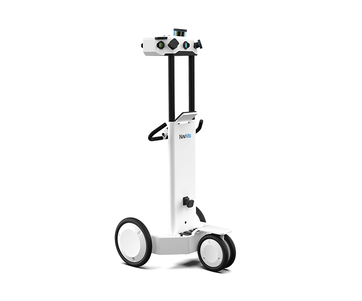
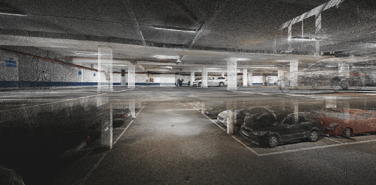
The NavVis M6 is an all-in-one system that captures 360 degree immersive imagery, photorealistic point clouds, Bluetooth beacons, WIFI signals and magnetic field data. The NavVis M6 features a mobile LiDAR system that lets it scan up to 30 times faster than stationary devices, letting users capture up to 30,000 square meters in a day.  What truly sets NavVis M6 apart is the cutting-edge 6D simultaneous localization and mapping (SLAM) technology, which significantly improves the quality of data captured. Thanks to 6D SLAM, M6 continuously scans even the most complex indoor environments, including uneven surfaces or changing elevations, such as ramps, open spaces or long corridors without compromising the quality of the data.

navvis_m6_panorama_pint_cloud

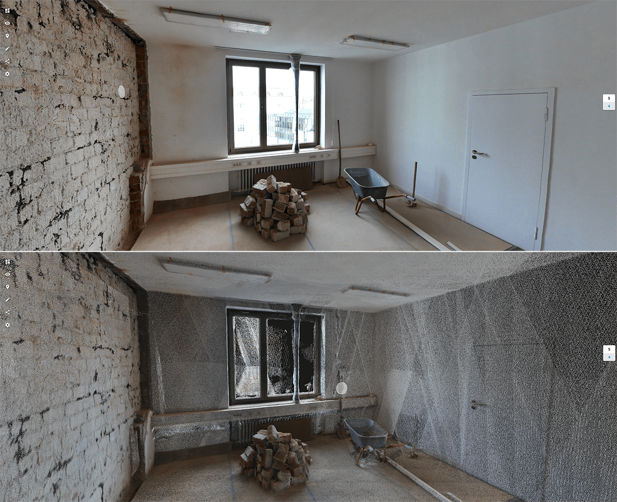
M6’s innovative software is complemented by hardware features designed to improve the quality of data and ease of capture: four laser scanners with a range of up to 100 meters are arranged to maximize scan coverage, while six cameras automatically take high-resolution images during mappings. The innovative design of the NavVis M6 includes camera placement that keeps the operator in a blind spot.

It is the perfect device for surveyors and AEC professionals who need to be able to capture large properties to update or create floorplans or as-built BIM models. At the same time, NavVis IndoorViewer software provides added value by giving every stakeholder access to the scanned environment through an interactive virtual building in their browser.

Dr. Felix Reinshagen, CEO of NavVis, said:

“The NavVis M6 marks a quantum leap in indoor mobile mapping. Anyone who needs to scan large properties, run repeated scans or would like to move into the field of reality capture will profit from the groundbreaking data quality. With NavVis M6, users can now quickly capture large, complex indoor environments for typical tasks such as updating floorplans, documenting construction progress or creating as-built BIM models. At the same time, NavVis M6 captures the data needed to provide customers with additional deliverables such as browser-based immersive walkthroughs and indoor navigation.”

Find out more: www.navvis.com/M6

navvis_m6_point_cloud

Subscribe now!

Be on top of the latest trends and news in the Mobile Mapping Systems World

RELATED ARTICLES

NavVis announces partnership with HERE Technologies to support the future of mobility
Press Release

3 min read

NavVis and HERE Technologies are working together to reshape transportation experiences.
NavVis adds fresh funding to fulfill its mission to digitize commercial buildings and assets
Press Release

3 min read

The funding complements NavVis’s recent debt funding from the European Investment Bank to solidify its technological leadership position, leveraging its...
NavVis VLX 2nd generation brings more versatility to reality capture
Press Release

1 min read

NavVis announces the launch of NavVis VLX 2nd generation, a mobile mapping system optimized for indoor and outdoor reality capture workflows.

Introducing NavVis IVION, the most powerful platform for spatial data
Press Release

3 min read

NavVis IVION, formerly known as NavVis IndoorViewer, is a supercharged new platform for owners, operators and contractors to transform all buildings and...

navvis-logo-new
  • Reality Capture
  • Digital Factory
  • Resources
  • Partners
  • Company
  • Careers
  • Contact
linkedin linkedin
twitter twitter
youtube youtube

© 2022 NavVis

Imprint

Privacy Policy