

The NavVis Reality Capture Solution enables AEC pros to compare point clouds and BIM models in third-party software for design & construction verification.
Architecture, Engineering and Construction professionals depend on complete transparency and reliable information to perform their work.
The NavVis Reality Capture Solution – consisting of the NavVis VLX mobile mapping system and the NavVis IVION Core spatial data platform – empowers AEC pros to compare their point clouds and Building Information Modeling (BIM) information in third-party software for design and construction verification.
Buildings aren't always constructed the way they were designed, usually because a project is executed based on outdated, incomplete plans for the existing site and surrounding area.
Here's where the ability to compare BIM models of design proposals against the "as-built" conditions on the site is so useful.
Applied before or during the construction phase, precise documentation of the site equates to fewer errors during construction.
With quicker detection of deviations from the plan, you can eliminate expensive, time-consuming reworks altogether - something every AEC professional can appreciate.
Design and construction verification made easy
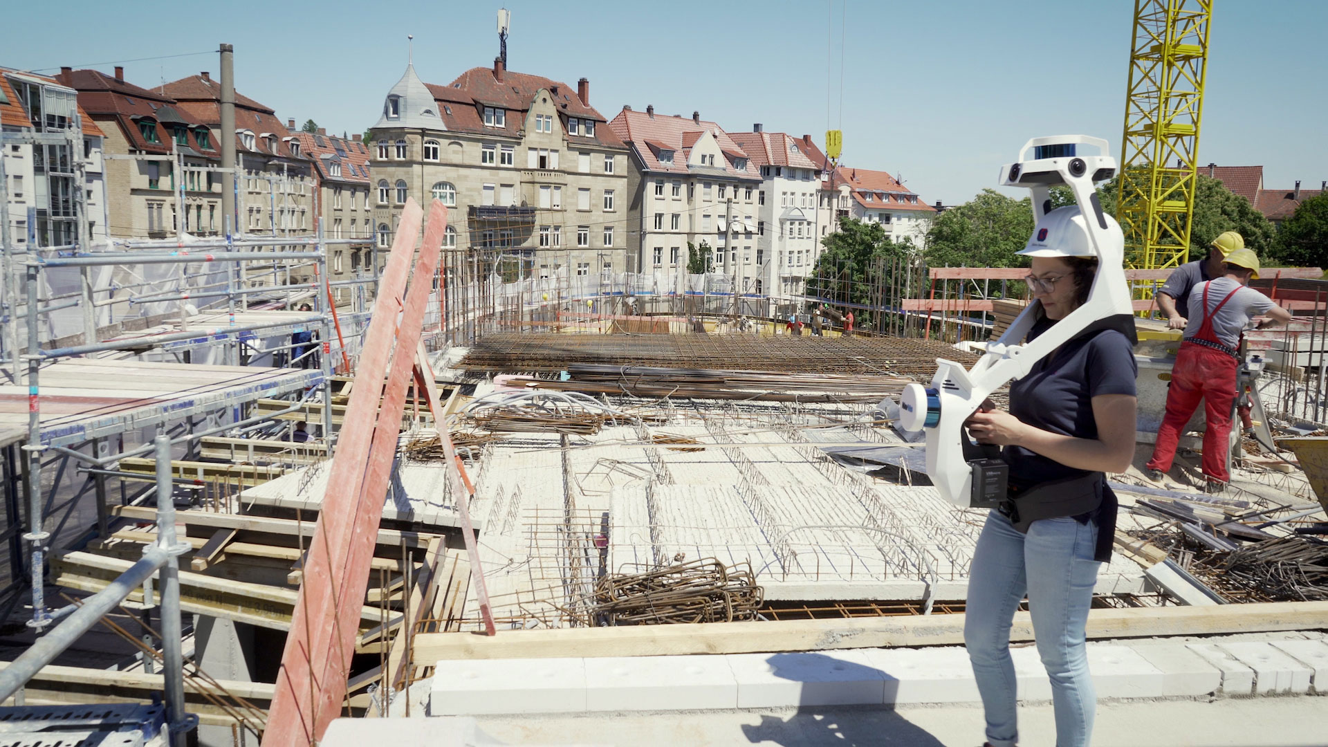
Now you know the "what", let's talk about the "how". With the NavVis VLX mobile mapping system, design and construction verification can be achieved quickly and at high accuracy no matter how complex the terrain.
With a robust Simultaneous Localization and Mapping (SLAM) algorithm that's as capable scanning outdoors as indoors, you can easily generate point clouds which are survey-grade quality.
Using control points, you also have the option to tie into the coordination points of the BIM model, so you have the basis for a common coordinate system later in the project.
Another benefit of using control points is that it improves the overall accuracy of your point clouds. Marks left by a surveyor at the construction can be reused for this exact purpose; no additional surveying work is required.
Crop and download point clouds for use with third-party software
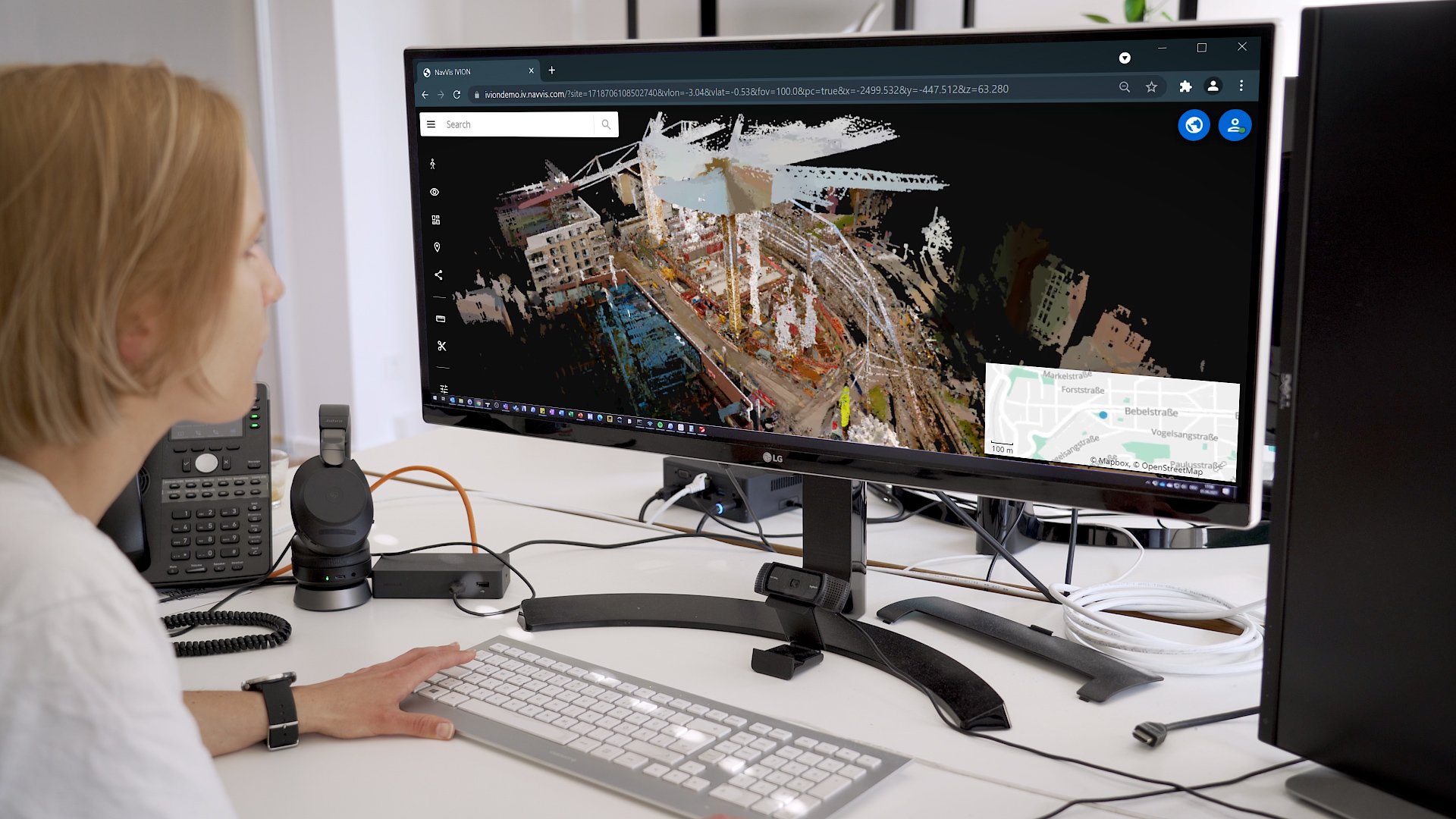
When you're done scanning and you've set up your instance in NavVis IVION Core you can double-check your measurements from the site, for example, or assess openings for MEP (mechanical, electrical and plumbing) systems.
The big advantage of NavVis IVION Core is that work like this can be conducted remotely, independent of whether you're located at the office or the construction site.
You can also sort and file data sets captured at various points in time, providing the ability to retrace the development of the project.
BIM modeling specialists, meanwhile, can focus on specific areas of interest using the crop and download function, exporting the data as a standard E57 file. This file can be imported into any third-party software used for construction verification.
Once it's been imported, you can either manually align the point cloud with the BIM model, or you can use control points so that the alignment in the verification software is handled automatically.
Regardless of which step you take, the result is a versatile hybrid model containing the point cloud, the BIM model, and all metadata required by the end client.
You can start the deviation analysis between the proposed BIM model and the as-built conditions pretty much instantly, using heat maps. You can also generate full color 2D floor plans if you're looking for a different perspective on as-built documentation.
Wrapping up
Using the NavVis Reality Capture Solution, data from NavVis hardware is perfectly suited for construction verification. Point clouds are accurate, high quality, and integrate with standard workflows to ensure that they're free from error.
And with open data formats like PLY and E57, NavVis supports your workflows independent of what software you might be using on the project.
With the power to effortlessly compare the physical state of the building to the project plans – and save budget and time in the process – NavVis offers AEC pros the best construction site documentation tools currently available.
With special thanks to Kappes IPG, Pflugfelder Unternehmensgruppe, and JSB Architekten for their support.