


Surveying and Reality Capture
Expand your workflows by integrating dynamic reality capture technology with traditional surveying methods to create precise representations of physical spaces, improving understanding, planning, and management of indoor and outdoor environments.
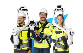
From capturing small projects and confined spaces to scanning larger, complex environments with superior detail, NavVis VLX and NavVis MLX offer a dynamic scanning solution for indoor and outdoor environments.
NavVis LX-Series
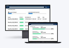
With NavVis IVION Processing, you can process, geo-register and automatically align scan data with survey-grade accuracy. Objects moving through the scan are automatically detected and removed during post-processing.
NavVis IVION Processing
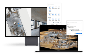
NavVis IVION transforms point clouds and panoramic images into intelligent spaces accessible from any standard web browser, speeding up model creation and delivery, and adding value to your data.
NavVis IVION

With NavVis IVION, achieve seamless integration and workflow compatibility. Gain access to a full range of downloadable data formats and the ability to export and import of points of interest with universally compatible file formats.
Partners
Surveying
As-built documentation & Scan-to-BIM

Construction documentation and verification
From capturing precise measurements to creating detailed 3D models of existing structures or construction sites, SLAM-based laser scanning has proven to be a valuable tool for construction documentation, combining high-definition panoramic imagery with reliable and accurate laser scanning data that professionals in the construction industry need to make informed decisions. Those responsible for documenting the current state of a site benefit from its ability to rapidly and accurately capture complex geometries and existing conditions throughout the construction lifecycle.
Surveyors and laser scanning experts similarly play a crucial role in the verification process, leveraging dynamic laser scanning to confirm dimensions and ensure the alignment of construction with approved plans. This integration of surveying and laser scanning expertise into the documentation and verification processes offers significant advantages in quickly and frequently gathering accurate as-built data that is up to date. It enables construction managers to monitor progress, foresee issues before they arise, streamline processes, reduce errors, minimize disruption and on-site risks, and improve overall project coordination.
Here is some content you might find interesting:
- (Blog | Jun 2024) Mobile mapping: Advancing the possibilities for building documentation
- (Blog | May 2024) Monitoring buildings over time with continuous digital scanning
- (Blog | Nov 2022) Can you measure floor flatness with NavVis VLX? We didn’t think so.
- (Podcast | 2023) Episode 02 - Overcoming BIMpossible | NavVis Scanning Realities
- (Podcast | 2023) Episode 01 - Capturing Realities | NavVis Scanning Realities
- (Webinar | Oct 2023) How surveyors and reality capture professionals can win more projects in construction
- (Webinar | Sep 2023) Improving efficiency and reducing rework in construction projects with technology
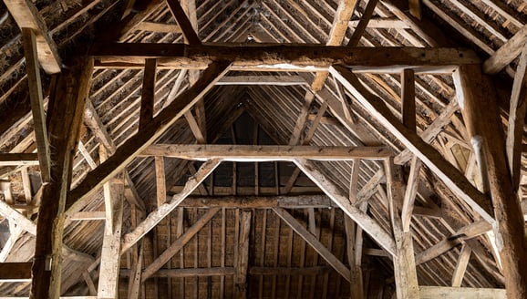
Heritage
Dynamic laser scanning provides a non-invasive, accurate, and highly efficient method for capturing heritage sites and buildings, both indoors and outdoors. It has proven to be especially useful for projects requiringextensive or detailed documentation while dealing with limited time on-site and tight budget constraints. Documentation generated from reality capture data enables the preservation of detailed 3D information such as measurements, features, and surfaces. The resulting digital models and visual representations can serve as references for documentation, restoration, or conservation of heritage sites.
Here is some content you might find interesting:
- (Case Study | June 2022) Rochsburg Castle: Built over 800 years, surveyed in three weeks
- (Case Study | May 2022) Capturing the castle with NavVis VLX
- (Sample Data | Sept 2021) Environment: Architectural landmark - Königsplatz Munich, Germany

Topographic
Urban topographic mapping often encounters challenges when using traditional surveying methods. These challenges include hazardous areas that are time-consuming to capture, rendering conventional techniques less effective. SLAM-based laser scanning minimizes the need for multiple site visits by capturing essential elements more comprehensively during the initial survey. This is crucial when elements were incorrectly specified or omitted from the original project scope. Dynamic reality capture complements and enhances traditional surveying methods such as static laser scanning and total stations, offering a more efficient and comprehensive approach to terrain data capture when integrated into topographic workflows.
The primary outcome of employing SLAM-based laser scanning in topographic mapping is the creation of detailed 2D and 3D maps and panoramic imagery. These deliverables accurately represent the terrain's geometry and features, whether a street or a building. The precise and detailed data obtained through this method is also valuable for a wide range of applications, including land surveying and infrastructure planning.
Here is some content you might find interesting:
- (Blog | Dec 2022) Asset Survey Solutions uses NavVis VLX to reduce time spent in hazardous environment by 87.5%
- (Case Study | May 2023) Capturing the castle with NavVis VLX
- (Sample Data | Jun 2024) Environment: Urban street - Munich, Germany
- (Sample Data | Feb 2024) Environment: Urban road - Los Angeles, USA
- (Guide) Everything you need to know about topographic surveying with SLAM scanners
- (Webinar | Apr 2024) Advancing Topographic Surveys: The Role of Wearable Mobile Mapping

Industrial facilities
Dynamic reality capture technology is a powerful tool for recording as-built information of industrial facilities and laying the foundation for digital twins. Its ability to quickly provide highly accurate 3D representations of complex industrial environments saves time, minimizes disruption, reduces costs, and enhances safety. The resulting point cloud data and panoramic imagery can be used to generate information-rich 3D models and 2D floorplans and drawings, serving as a digital record for future reference.
Combined with powerful software solutions, SLAM-based laser scanning hardware empowers professionals to move away from intensive modeling workflows and make informed, real-time decisions based on current data. This integration of hardware and software optimizes the documentation process and ensures consistent, accurate information is available for activities such as facility management, regulatory compliance, and factory remodeling.
Here is some content you might find interesting:
- (Case Study | May 2024) Oil and gas giant upgrades complex project planning with NavVis VLX
- (Blog | Jun 2022) NavVis Digital Factory Solution is a key building block for the production of the future
- (Sample Data | Sep 2023) Environment: Process facility - Rotterdam, Netherlands
- (Sample Data | May 2023) Environment: Water treatment facility - Aarhus, Denmark
- (Guide) NavVis | Digital Twin use cases
- (Podcast | 2023) Episode 03 - Powering progress | NavVis Scanning Realities

Infrastructure and transportation
SLAM-based laser scanning provides a powerful solution for infrastructure and transportation applications, enabling the creation of detailed 2D and 3D models of various infrastructures, including streets, bridges, and buildings such as train/subway stations and airports. With much of today’s extensive, aging infrastructure built before the introduction of CAD (Computer Aided Drawings), many projects begin with little to no digital documentation. Thanks to its revolutionary reality capture capabilities which quickly generate rich spatial data, this technology optimizes asset management and process monitoring and aids in urban planning and design. The ability to capture detailed 3D data in real-time makes it an essential technology in modern infrastructure and transportation sectors, where minimal disruption of operations and reduced time spent in hazardous environments are crucial.
Here is some content you might find interesting:
- (Webinar | Nov 2023) Transforming Infrastructure Surveys with SLAM Laser Scanning

Existing buildings & building measurement surveys
Dynamic laser scanning systems powered by SLAM offer several advantages for capturing and generating data of existing buildings. These include faster data acquisition, increased project efficiency, and the ability to comprehensively capture a variety of complex environments. It is ideal for capturing indoor spaces, exterior building facades, or large-scale urban projects where the exclusive use of a traditional static scanner may be unnecessary, impractical or time-consuming.
Here is some content you might find interesting:
- (Blog | Jun 2022) NavVis VLX powers the digitization of a neighborhood in Shijingshan District, Beijing
- (Case | Feb 2023) Existing Conditions' historic building capture with NavVis VLX
- (Case | Sep 2022) IBKS pushes the boundaries of scan-to-BIM in a towering project
- (Data | Nov 2022) NavVis VLX 2 point cloud data: Modern architectural housing
- (Guide) The definitive guide to scan-to-BIM
- (Webinar | Nov 2023) The ultimate building measurement survey workflow
- (Webinar | Feb 2023) NavVis + IBKS + PointFuse: Pushing the boundaries of scan-to-BIM